Allegheny Front Trail: A Hidden Gem Backpacking Loop in Central Pennsylvania

If you’re searching for a new backpacking experience in Pennsylvania, the Allegheny Front Trail should be your next adventure. In the heart of central Pennsylvania, this trail is more than just a short hike through the woods.
From sweeping vistas that stretch across those stunning central PA valleys to the quiet beauty of trout streams and marshlands, the Allegheny Front Trail offers a diverse landscape that keeps every step interesting.
We knew we were in for a unique adventure when we first set foot on this nearly 42-mile loop trail. The yellow blazes guided us through dense forests, across rocky ridges, and along streams galore. And those bog bridges? They’re not just functional—they add to the adventure, leading you across swampy terrain you usually wouldn’t get to see.
We’ve hiked it all, from the steep climbs that tested our legs to the quiet, flat sections where we had a little time to breathe and listen to the rustling leaves.
Whether you’re an experienced backpacker or just looking for a new challenge, the Allegheny Front Trail is the perfect place for a weekend-long trip. Trust us—once you’ve explored it, you’ll be planning your next trip before you finish the first.
Where is the Allegheny Front Trail?
The Allegheny Front Trail is located near Philipsburg, PA, about 30 minutes northwest of State College in central Pennsylvania.
There is relatively easy access provided to the area by Interstate 80. You can arrive at access to the Allegheny Front Trail within 15-20 minutes after exiting the interstate.
How long is the Allegheny Front Trail?
The Allegheny Front Trail covers nearly 42 miles and loops around Black Moshannon State Park.
If you’re not up for the full 42 miles and want to cut down on distance, Black Moshannon State Park has a trail through the center where you can divide the Allegheny Front Trail into an east and west loop. Each of these two loops comes in around 30 miles.
How long should it take you to hike the entire “almost” 42-mile loop of the Allegheny Front Trail? We’d recommend 3-4 days, though some quick and ambitious hikers have hiked it in 2 days.
Complete Trail Description
Much of the trail crosses gently rolling terrain, with just a few exceptions!
The section to the northwest, along the river before crossing Casanova Road, is quite rocky and has plenty of elevation change both up and down. It feels like quite a feat if you’re crossing this section towards the end of your hiking day on tired legs!

The other section that we’d consider more difficult is between the vistas and the Tram Road parking lot. Loose rocks, steep inclines, followed quickly by descents, keep things interesting.
The trail follows yellow blazes. In some areas, especially in the northeast corner, the trail overlaps with others and may be double-blazed in sections. Follow the yellow blazes!

The trail overall is well-marked. We had no trouble following the blazes, for the most part. The one spot where people get hung up is on the northern part of the loop if going counterclockwise.
After crossing Meyers Run Road and walking along the wide trail/dirt road for some time, the trail takes off down the hillside on a single track towards the Red Moshannon Creek. A stack of rocks marks the turn on the ground to the left side of the trail, also marked with a yellow blaze.
We almost missed it ourselves, but we happened to see a yellow blaze on the next tree just down the hill. Otherwise, who knows how long we would have walked off the trail?
Logistics: Planning Your Trip on the Allegheny Front Trail
Here is everything that you need to know to plan your adventure on the Allegheny Front Trail. Parking can be found close to the trail. Campsites are plentiful, and a spot to refill your water is generally close by.
Parking to Access the Allegheny Front Trail
There are multiple places where you can access the Allegheny Front Trail. One of the most popular parking lots is the Tram Road lot, located on Route 504/Rattlesnake Pike east of Black Moshannon State Park. It’s right on the main road, and there is no extra hike to access the trail; it runs through the parking area!

There are no parking areas directly on Route 504 west of Black Moshannon State Park, where the trail crosses the road. We recommend using other spots as your access point.
Some of the most commonly used parking lots for accessing the Allegheny Front Trail include:
- Tram Road Lot
- Underwood Road Lot
- The intersection of Beaver Road and Shirks Road
- Intersection of Shirks and Dug Rd
- Six Mile Run Road near Wolf Rocks
Parking is also available in Black Moshannon State Park if you are following either the east or west loop. Just notify the park office ahead of time that you will be heading out on the trail so they’re not suspicious of an abandoned vehicle!
Trail Water Sources
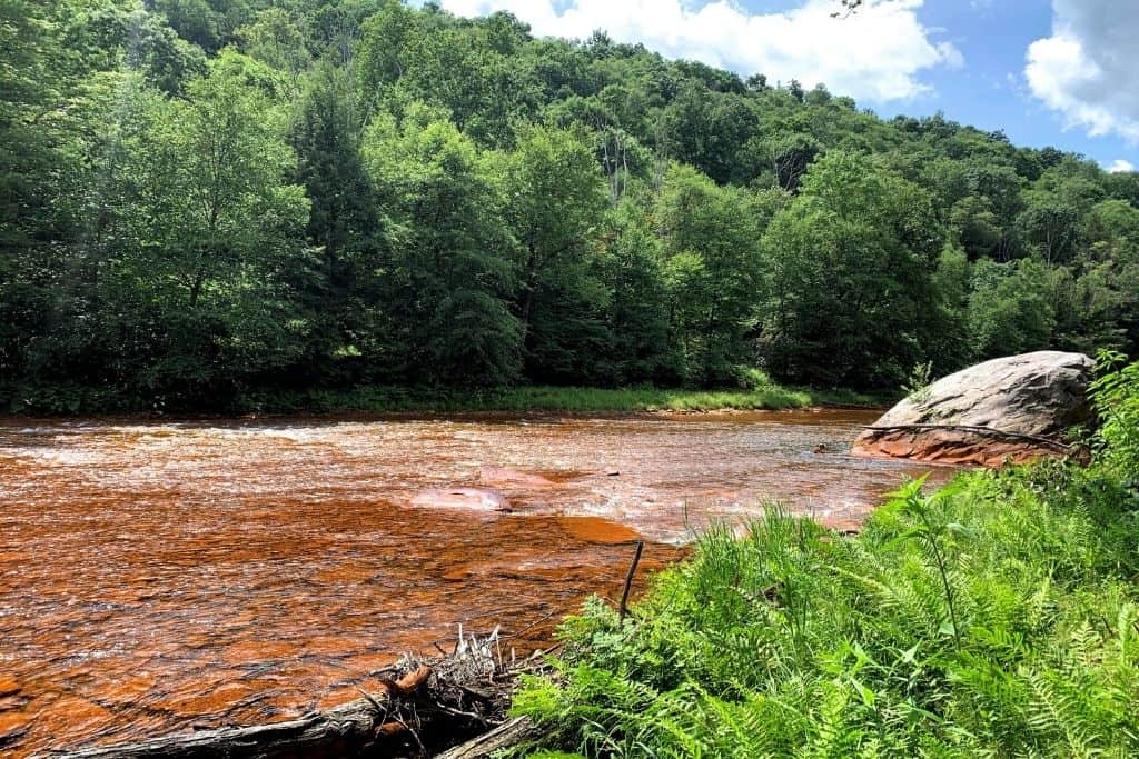
There are plenty of sources of running water along the Allegheny Front Trail, but some are much safer to drink from than others! As a safe bet, don’t drink water from the red stream!
The exception to the plentiful water sources is along the 6-mile stretch of trail spanning between Smays Run and Benner Run on the southern side.
Along the northern section, for a stretch, you’ll travel along Moshannon Creek, nicknamed the “red Mo.” The water in this creek has stained everything a bright red-orange color. This is pollution-related from abandoned mine drainage.
The water is highly acidic and full of heavy metals, so much so that fish cannot live there. This classifies it as a “dead waterway.” Would you want to drink that water if fish can’t survive?
We definitely wouldn’t recommend it.
While hiking this trail, you’ll spend plenty of time along creeks and streams, including Six Mile Run, Black Moshannon Creek, and Rock Run. Little planning is required to ensure that you always have enough water.
The work of beavers is very much evident along the trail. It is essential to filter water along the trail to be safe and avoid any possible waterborne illnesses.

We’ve had great results with our Katadyn Hiker Microfilter!
The best part? The hose hooks directly to our water bladders, and we don’t have to remove much from our packs to replenish.
Also, refilling is quick!
Campsites & Hiking along the Trail
There are plenty of campsites to choose from, all along the trail. Most are located near the best sources to refill your water, making it convenient to cook a hot dinner and then begin your day with a full water bottle or bladder.

On our most recent trip around the AFT, we began on the eastern side of the loop at the Tram Road parking lot on Route 504 and headed counterclockwise.
Here is the one main pro and con of taking this route:
Pro: Saving most of the beautiful vistas for the end motivated us to complete the hike.
Con: The two most challenging sections of the trail were crossed while we were hiking tired, at the end of the first day, and in the last few hours of our adventure.
Typically, campsites on the trail are at most 5 miles apart, with many being much, much closer together than that. This is not an all-inclusive list, either.
We love our NatureHike Cloud backpacking tent for these trips. Set up and tear down are so easy. The rainfly works exceptionally well, even in a downpour. On beautiful summer nights, leave the rainfly off to enjoy fresh air and gaze up at the stars through the mesh top.

Here are the approximate distances to the campsite clusters from the Route 504 trailhead (Tram Road lot) so that you can plan appropriately, depending on your abilities.
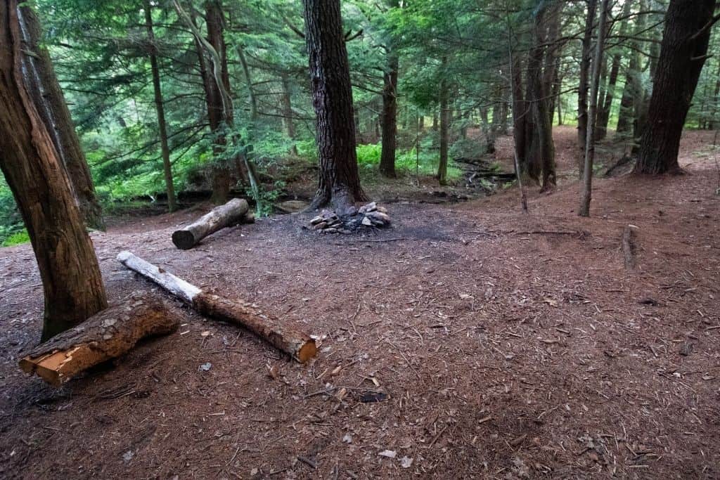
The easiest way to find the commonly used campsites is to look for rustic rock circle fire rings just off the trail. You’ll know them when you see them.
The first campsites will come between miles 3-5 along Rock Run. You’ll be able to find 4-5 campsites in this 2-mile stretch.


Near miles 8-9, a couple of campsites can be found on the left side of the trail along Benner Run.
Around mile 9.5, you’ll pass by a small cabin nestled in the woods and immediately cross Black Moshannon Creek on a small footbridge. Initially, you’ll see a great campsite with tons of room right at the end of the footbridge, opposite the cabin. If this one is already occupied and you prefer to have your own space, continue along Black Moshannon Creek, and over the next mile or so, you’ll find a couple more options.

At just over 10 miles, you should find a trail mailbox register near the junction with the Shingle Mill Trail, leading to Black Moshannon State Park. Numerous campsites are along this stretch before the state park boundary if you’re still looking for somewhere to turn in for the night.
The next campsites will require a little more of a hike, and you’ll reach them near miles 14-16. These are found on the difficult stretch traveling along the “red Mo,” so you will need to scope out the water situation a little more closely if this is where you stop to spend the night.
Around mile 17, you’ll cross the small country road, Casanova Road. There is a very short stretch of road walking here.
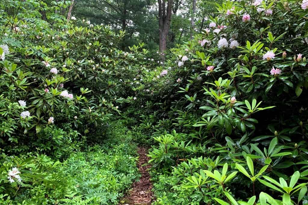
After crossing the road, you’ll head down along the stretch of trail, weaving along Six Mile Run. There are multiple campsites along this stretch of trail, nestled under tall trees and among patches of rhododendrons. The large campsites here can accommodate multiple tents and are right along Six Mile Run for water.

We settled in at one of these campsites for night #1 of our trip, and estimated we hiked around 18 miles on day #1.
One thing to note regarding these campsites along Six Mile Run: Six Mile Run Road is just on the other side of the creek, on the hillside. You cannot really see the road from the campsites when everything is green.
If cars pass along the gravel country road, you can hear and possibly see the vehicles. We didn’t realize the road was quite so close until a vehicle drove on it. If this will hinder your hiking experience along the trail, we recommend planning to stay at a different campsite.
Continuing along the trail, you’ll come to the west Route 504 crossing around mile 20. As you cross the road, you might think you are trespassing on private property, heading towards a cabin on their driveway. Stay to the left, head back into the woods along the creek, then up the hillside.

The trail eases off, and you’ll pass through more manageable sections. Camping is sparse in this stretch. You won’t find another site until just before reaching Shields Dam Road, around mile 23. We’d only recommend this campsite in a pinch. There are much better ones along the trail.
When you reach Shields Dam Road, take a right and walk up to the T in the road, where it meets Six Mile Run Road. The trail continues into the woods across Six Mile Run Road. We found this section a little confusing. What is labeled Clay Mine Road on the map could be mistaken for a trail.
Around mile 27, cross over Horse Hollow Road and through Wolf Rocks.

After Wolf Rocks, the trail dips down into the Hemlocks along another stream, and there are beautiful campsites around mile 28.
Next comes a long stretch without great camping that heads towards Black Moshannon State Park. You’ll have to do some road walking on a dirt/gravel road just before the state park. Exit the woods and continue right on the gravel road, past a cabin on your left, and across a bridge/section with a guard rail. The trail will continue about 100 yards past the guard rails on your left.
This marks the 3-mile or so stretch through the state park. Even in the driest seasons, this section can still be wet and muddy. Boardwalks have been installed over some sections of the marsh, but you still may get wet or muddy feet. No camping is permitted along the trail in the state park.
Crossing Julian Pike, a paved road around mile 35, marks your exit from Black Moshannon State Park. In this section, you’ll notice trail post markers with distances back to Route 504. It feels like a countdown, a welcome sight.
As you continue, you’ll see the Smays Run Trail intersection, with the Underwood Road parking lot just up the trail to the right. You’ll want to continue straight (unless you decided to park there, of course).
Head through this easy section, and you’ll also find a few beautiful campsites along Smays Run, tucked among the hemlocks after crossing a small wooden footbridge. This is where we spent night #2 on the trail, and we estimate that we covered another 18 or so miles on day #2.
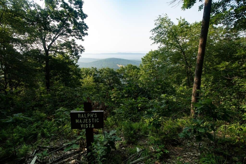
After this stretch of trail through the hemlocks, prepare for a climb, where you will head toward the edge of the Allegheny Front. You’ll reach the first vista around mile 37, Ralphie’s Majestic Vista.
There will be a few more vistas over the next couple of miles. We thought this section, from the vistas to the crossing of 504 (where our car was parked), was the most challenging section of the trail. It is incredibly rocky and covers some steep climbs and drops.
There are a few campsites along this section near the vistas, around mile 38 or so, but you’ll have to work a little harder to get water here. It would be a beautiful spot to watch a sunrise, though!
One last climb up a wide, grassy path, and you’re back at your vehicle!
Celebrate a little! You’ve completed your hike on the AFT!
Splitting the AFT into Sections
Splitting the Allegheny Front Trail into two sections, the east and west loops, is possible. If you are looking for a shorter trip for backpacking beginners or only have a short weekend to explore, consider splitting the trail into two smaller loops for two separate adventures.
Both sections are about the same distance, landing you around 30-ish miles for each trip.
The eastern loop highlights include the vistas along the edge of the Allegheny Front and hiking through thickets of rhododendrons.
Through the western loop section, you’ll be treated to views of the “red” Moshannon Creek, Six Mile Run, and Wolf Rocks rock formations.
To make these loops possible, you’ll need to take the Moss Hanne Trail on the southern side, blazed in orange, and the Shingle Mill Trail on the northern side, blazed in blue. These trails cut right through Black Moshannon State Park, an easy spot to begin and end each loop.
Again, no camping is permitted along these connector trails in the state park. The only camping allowed on Black Moshannon State Park grounds must be in the designated campground.

Where else can you backpack in Pennsylvania?
Pennsylvania has a ton of options for overnight, multi-night, and thru-hike-type trips!
For a shorter backpacking trip, head to the north-central part of the state, to the Pine Creek Gorge. Also known as the Pennsylvania Grand Canyon, the West Rim Trail is a beautiful trail that is 30 miles long. The trail skirts Colton Point State Park through the Tioga State Forest, and it’s one of our favorite weekend trails.
The Laurel Highlands Hiking Trail begins on the southern end in Ohiopyle and Ohiopyle State Park. This trail is 70 miles long and travels east through the Laurel Highlands region towards Johnstown. Particularly beautiful in the fall, it’s also known as part of the Potomac Heritage National Scenic Trail (PHT).
The Standing Stone Trail is not far away and runs from Cowans Gap State Park to Greenwood Furnace State Park, south of State College. This trail crosses central PA ridges and has numerous stunning vistas. It’s a challenging trail to hike, spanning 84 miles long now and 3 counties!
For long thru-hikes, trails such as the Appalachian Trail, North Country Scenic Trail, and the Midstate Trail all traverse the state, too!
The AFT: Final Things to Know Before You Go
- We prefer to get out on the trail early in the morning. If you prefer to arrive a day early (like we did, arriving late on Friday night and setting out on the trail early Saturday morning), the established campground at Black Moshannon State Park has a nice little tent camping loop with nine sites. It’s a great place to set up camp for a night, especially if you plan to arrive after dark.
- Sturdy, waterproof footwear is recommended for this trail because of the rocky sections in the northwest and southeast. Blisters from wet boots and socks are no joke. We speak from experience.
- Although hiking this trail in 2-3 days is doable if you have experience, we think spending 3 nights out here would be perfect. We could have stopped and enjoyed so many beautiful stream-side campsites a little longer. Take advantage of the beautiful settings!
- If you have to travel any distance home after your hike on the AFT and you’re visiting during the summer months, head back to the beach at Black Moshannon State Park. There is a bathhouse by the beach where you can shower and change clothes before traveling.
Should You Plan A Trip on the Allegheny Front Trail?
The Allegheny Front Trail provides stunning vistas, beautiful waterway views, and is a great introduction trail for backpacking. We’d recommend making this your second backpacking trip after trying it out on a short overnight somewhere like the Allegheny National Forest.
Anyone could backpack this trail with planning and preparation!
Is there anything else you need to know before heading out on the Allegheny Front Trail?