Everything you Need to Know About Hiking the Standing Stone Trail in South Central Pennsylvania + Day Hike Suggestions!

Part of the Great Eastern Trail network, the Standing Stone Trail (SST) is an 84-mile-long hiking trail spanning three Pennsylvania counties.
Those looking for a 7-10 day adventure across the south-central Pennsylvania mountains, or even a challenging day of hiking some of the connecting sections, should check out the Standing Stone Trail. From stunning vistas to historical pathways, the Standing Stone Trail is a great multi-day hike connecting to other long-distance trails in the region.
We’ve loved exploring the Standing Stone Trail, whether day hiking or on a longer adventure. Without further ado, here is all the information you will need to plan your adventures on the Standing Stone Trail.
Best Day Hikes on the Standing Stone Trail
1,000 Steps

One of the most popular hikes on the Standing Stone Trail is undoubtedly the Thousand Steps.
Yes, the name also means exactly what you are thinking.
This trail travels up over 1,000 stone steps lodged into the side of Jack’s Mountain.
The stairs were not built just to be a hiking trail. Originally, they were constructed and used by sandstone quarry workers around 1936 to ease their daily commute to work. People used to do this climb daily, and then perform difficult physical labor at the stone quarry.
Think about that as you climb the steps, huffing and puffing.
A large parking area is available at the bottom of the trail, just east of Mapleton on Route 22. The trail begins at the far end of the parking area.
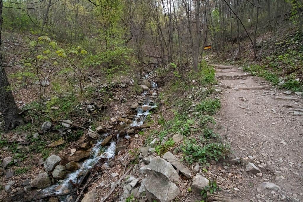
At the beginning of the trail, you’ll find a small water feature to the left.
There is also a site with historical information not far from the bottom, which is worth stopping to read.
At the top of this out-and-back trail, after climbing the 1,000 stairs, there are two points of interest you should be sure to see. You did hike all the way up there, after all!
First, head to the right following the blue marked trail less than 100 yards and you will be treated to views of the Juniata River and the town of Mapleton below through Jack’s Narrows.

Return the way you came to the top of the steps and continue in the opposite direction to see the Dinkey Shed.
This small stone structure was used as a repair shop for the trains transporting stone from the quarry. The area in the middle, now filled with dirt and stones, used to be empty so that repairmen could easily climb underneath the train cars to perform any necessary maintenance and repairs.

After exploring these two points, you can either continue up the hill past the Dinkey Shed for more wooded hiking or retrace your steps to the bottom of the mountain.
This hike could be as short as 1.5 miles, but your legs will feel like Jell-O at the end! I know ours did!
Throne Room Vista
One of, if not the best vista, on the Standing Stone Trail is the Throne Room.

The shortest way to reach this vista is by parking at the trail opening on Jack’s Mountain Road and hiking about 1.5 miles back south on the trail.
Jack’s Mountain Road is all dirt and not well maintained, so in inclement weather, 4WD and/or high-clearance vehicles would be helpful.
The trail begins on a logging access or ATV road. It is flat and easy to navigate, which is quite the opposite of the rest of the hike.
After about 3/4 mile on this path, be sure to pay attention on your right, as the trail cuts up the hillside on a single track. It could be easily missed, as the wide path continues on.


The rest of the hike to the vista is a fairly steady and often steep 0.7-mile climb to the top.
There are three separate vistas in just a short span here along the tallest ridge on the trail.

This would be a great spot to stop for lunch on the rocks, before returning to your vehicle.
Alternatively, parking is available off of Jack’s Tower Road, and for a longer hike, continue north past Jack’s Mountain Fire Tower to catch the same stunning views from the opposite end.

Rocky Ridge Natural Area
For a short, but still somewhat challenging, hike head to the Rocky Ridge and 3 Sisters Natural Area.

Parking is available on the side of Frew Road in the State Forest where the trail crosses the road. There is room here for 8-10 cars to easily pull off the side of the road.
The hike begins on a flat stretch, but after crossing a small stream, quickly begins an uphill climb.
After reaching the top, you will be greeted by huge rock formations jutting up from the forest and ridgeline.

The Standing Stone route leads over, around, and through the boulders.
A yellow-marked bypass trail leads just below the formations, so you can see them from a distance without scrambling. The bypass is also known as the Dogwood Trail and could be used to turn this hike into a short loop.

Though the hill climb can be challenging, your kids would likely have a blast climbing the boulders.
This hike covers about 2 miles, but that depends on how much you choose to explore!
In spring and early summer, the area boasts spectacular displays of wildflowers. Just another reason to visit!
Greenwood Furnace Loop
Towards the northern end of the trail, before setting out on the Greenwood Spur, you can make a loop trail including some of the Greenwood Furnace State Park trails. This route is a great five-mile workout.
Plenty of parking for this hike is available, located across PA 305 from the Greenwood Furnace Park office.
We’d recommend hiking this route “backward.”

Head down the Standing Stone Trail at the far left end of the parking area, and before leaving the wooded area, take the yellow-marked Monsell Trail up the hill as seen in the photo above.
The Monsell Trail leads to the Lorence Trail on the left, which continues for one mile through heavily wooded hillsides.

At the four-way intersection with the Turkey Trail, take the left up the steep Turkey Trail.
Towards the top, there are both stone steps and switchbacks to navigate.
At the top of the hill, you’ve reached the intersection with the Standing Stone Trail!
Take the trail left, and just a half-mile on this stretch, which is much flatter at the top, leads out to the beautiful Stone Valley Vista.

A trail register sits at the overlook. Make sure you sign it while you enjoy the views! Cross the rocks, through a stretch of hemlocks, and pass the more difficult portion of the two-mile downhill drop, returning to the parking lot.
Near the end, you’ll pass the Greenwood Furnace Church, built in 1867. Make a quick pit stop to learn a bit about the history of this building before returning to your car.
Cowan’s Gap Loop
This loop begins at the southernmost trailhead for the Standing Stone Trail in Cowan’s Gap State Park. Here, the trail also connects to the Tuscarora Trail.
If parking at the main visitor’s center by the beach, take the Tuscarora Trail along the north end of the lake.

The Standing Stone Trail entrance to begin this hike is just across the spillway bridge at the northwest corner of Cowan’s Gap Lake.
The hike passes along the western edge of the lake, then turns right at the far end to follow what appears to be an old logging path up the hillside.

You’ll pass unique-looking remnants of a rock slide that occurred in 1996 and a CCC incinerator along the way, before reaching the Cowan’s Gap Overlook.
This overlook would be a great place to catch a sunrise over Cowan’s Gap for you early risers like us!

After stopping at the overlook, continue on the trail to the top of the ridge.
You’ll notice multiple trails heading in different directions, but be sure to follow those orange markers.
If this is your first taste of hiking on the Standing Stone Trail, this section of the trail provides a good taste of the rocky ridgelines along the entire length of the trail, but only for a short distance.

To return to Cowan’s Gap State Park, take the Horseshoe Trail to the right back down a very steep drop, eventually taking you back to the Tuscarora Trail.
This hike covers about 3.5 miles but could be extended for a longer hike by continuing on the Standing Stone to the Wagner Trail, which also connects to the Tuscarora.
Stone Mountain Hawk Watch

From a parking area on the Mifflin-Huntington County line on Allensville Road, follow the orange-blazed trail to the left through the woods and across a rock field for about 1/4 mile.
Stay on the trail across the narrow ridgeline will lead to the Stone Mountain Hawk Watch platform, built by local birdwatching groups.
The hike to the lookout is quite short but provides beautiful views of the mountains and valleys beyond from an elevation of 2100 feet.
Although the hike is short, this is a very popular spot for birding enthusiasts, so plan to spend some extra time accordingly if this is an activity that you also enjoy.
This is also one of the more accessible portions of the trail for hikers of many ability levels.
Monument Rock
Honestly, if we had to leave one hike off the list, this would be it. Since Monument Rock is what the trail is named for, though, it is included here.
To make this hike a day hike, begin at the Ramsey Path trailhead on Sinoquipe Road.

This trailhead is difficult to find. The “parking area” is really just pulling off the side of the road, and there is only room for a couple of cars to do so. The signage for the trailhead is also back a few feet from the road, and there isn’t really an opening in the woods, so it’s extremely easy to miss.
You’ll find the Ramsey Path trailhead near the location above. Keep a lookout for the sign back off the road, on the right when heading north.
Also, please note: part of this trailhead passes through privately owned land, so be respectful and stay on the trail!
This hike also covers about 2 miles, depending on how much exploring you do, and passes by boulder-covered hillsides in addition to Monument Rock.
It’s not extremely tall or noteworthy but is the trail namesake, so some may be more enticed to visit than others.
Thru-Hiking the Standing Stone Trail
Marked entirely by orange blazes, the Standing Stone Trail crosses between two State Parks, through State Forests and Game Lands, as well as over privately owned lands.
A step up (or multiple steps up) from the PA Grand Canyon’s West Rim Trail or the nearby Allegheny Front Trail, this is a more challenging backpacking trail in Pennsylvania traversing rocky ridges from one stunning vista to the next.
When planning your daily mileage goals and itinerary, plan conservatively. Covering the whole thing in anything less than 8 days would be ambitious for most hikers.
Restocking supplies is possible in the towns of Mapleton and Three Springs.
Mapleton is located centrally on the trail, while Three Springs is toward the southern end. Some road walking is required to thru-hike the SST, with 5-6 miles of it directly south of Three Springs.
Some of the southernmost stretches of the trail also cross private farmland, and stiles are built over the fences (a setup that looks like a ladder on one side and a few stairs on the other) to help scale them.
There are a few spots where three-sided shelters have been built for overnight accommodations, and suggestions for nearly 20 camping spots along the trail can be found on the club’s website.
A note regarding camping: Overnight stays are not permitted on State Game Lands, so be sure to know the boundaries when setting up your tents for the night.
There aren’t yet official printed maps for this trail because rerouting and trail work are still happening. Free, printable versions can also be found on the trail website.
Where Should Your Hike Begin?
The preferred hiking direction for most is from south to north, beginning at Cowans Gap State Park and trekking north.
At the southern end, the trail connects with the Tuscarora Trail, a 250+ mile alternative hiking route to the Appalachian Trail that passes through four states.
The northern end passes through Greenwood Furnace State Park and continues on the Greenwood Spur.
The Standing Stone Trail eventually terminates at Pennsylvania’s Midstate Trail, which covers 323 miles and also connects to others like the Finger Lakes Trail at the New York border.
Parking is available at the State Parks at each end of the trail for free at the visitor’s centers. Just be sure to notify the visitor’s center that you are thru-hiking so that your car doesn’t get ticketed or towed!
Hazards on the Trail
Black Bears

Though an uncommon sight in the Pennsylvania woods, black bears are creatures to be conscious of while hiking here.
This is more of a concern for those thru-hiking and camping, so knowing how to hang a bear bag for food and any other scented items you’re carrying is an extremely useful skill here.
Particularly a concern during spring and early summer when cubs are small, it is important to be aware of your surroundings and not find yourself between a mama and her cubs.
Otherwise, black bears will typically be long gone before you even catch a glimpse of them.
Timber rattlesnakes

One of three venomous snakes endemic to Pennsylvania and the surrounding areas, timber rattlesnakes can be found especially during the summer months on the rocky ridgelines of the Standing Stone.
The female snakes enjoy basking in the sunshine on the warm rocks.
Typically, you’ll hear the snakes before you see them, which gives you plenty of time to avoid them but take caution nonetheless.
Being bit by a timber rattlesnake can be deadly, so seeking medical attention immediately is crucial if such a medical emergency should occur. We always recommend having a satellite communicator like the Garmin inReach2 in case of an emergency like this! We love ours!
Identify these vipers by their wide heads, yellow ellipse eyes, and V or W-striped markings down the back. They also typically grow to 3-5 feet in length.
Severe Weather

Severe weather on the Standing Stone Trail can be hazardous for a few reasons.
First and foremost, being at the top of the ridgelines leaves you extremely exposed to the elements including heavy rains, wind, and lightning.
The rock fields are very exposed, and crossing one in the wind and rain could be treacherous. One wrong step could result in serious injury with no way to call for rescue. Another reason why you should carry a satellite communicator like the inReach!
Poison Ivy

As with any hiking done in rural Pennsylvania, be sure to keep an eye out for poison ivy, especially when going off-trail for campsites or using the restroom.
Identify it by its three large leaves, with the one in the center usually the largest. The tips of the leaves are typically pointed.
Rashes occur when a person comes into contact with the oil, urushiol, secreted by the plant. Symptoms typically develop within 2 days. Rashes from poison ivy can be very red, itchy, and blister, sometimes lasting 2-3 weeks.
This would be quite an unpleasant way to spend your time on the trail, so do yourself a favor and know what to look for before your trip!
What to Pack for Your Standing Stone Trip
Trekking Poles: Your quads and knees will thank you on the steep ascents, descents, and boulder field crossings.
Sturdy Closed-Toe Footwear: I love my Chaco’s as much as the next person, but they’re not appropriate for this trail. The rocky terrain combined with the chance to encounter a rattlesnake? Just don’t do it.
Extra Ways to Carry Water: Some of the water sources are as far as 10 miles apart, which can be quite far in the summer with 90-degree temperatures.
Insect Repellant: During the warmer months, the insects and ticks on the trail can be quite nasty, so repellant can make them significantly more tolerable.
History of the Standing Stone Trail
The Standing Stone Trail originally came to be in the 1970s but went by a different name.
Originally known as the “Link Trail,” literally linking the Tuscarora and the Midstate trails, the name was changed in 2007.
Much of the area is rugged with a deep industrial history, with many old iron furnaces dotted along. You even pass right by one on the Greenwood section of the trail.
One of the most notable sections, the Thousand Steps segment, was built by stone quarry workers in the mid-1900s to ease their commute up the mountain to work every day.
In the 1990s the trail was almost left abandoned and overgrown, but it is now entirely maintained by a club of volunteers who do a great job keeping it accessible.
Hiking the Standing Stone Trail
Whether planning an intense thru-hike or an exciting day hike on the SST, you will certainly not be disappointed by the views and the scenery.
Some stretches are quite challenging, while others have been cleaned up and rerouted. Some pass along old logging and ATV roads. Stunning vistas and a little touches of history can be found all along the Standing Stone Trail.
Quickly becoming one of the premier backpacking trails in Pennsylvania, the SST should not be missed by either backpacking enthusiasts or adventurous day hikers!
Have you hiked any of the Standing Stone Trail or even thru-hiked it?
What are your favorite Pennsylvania backpacking trails?