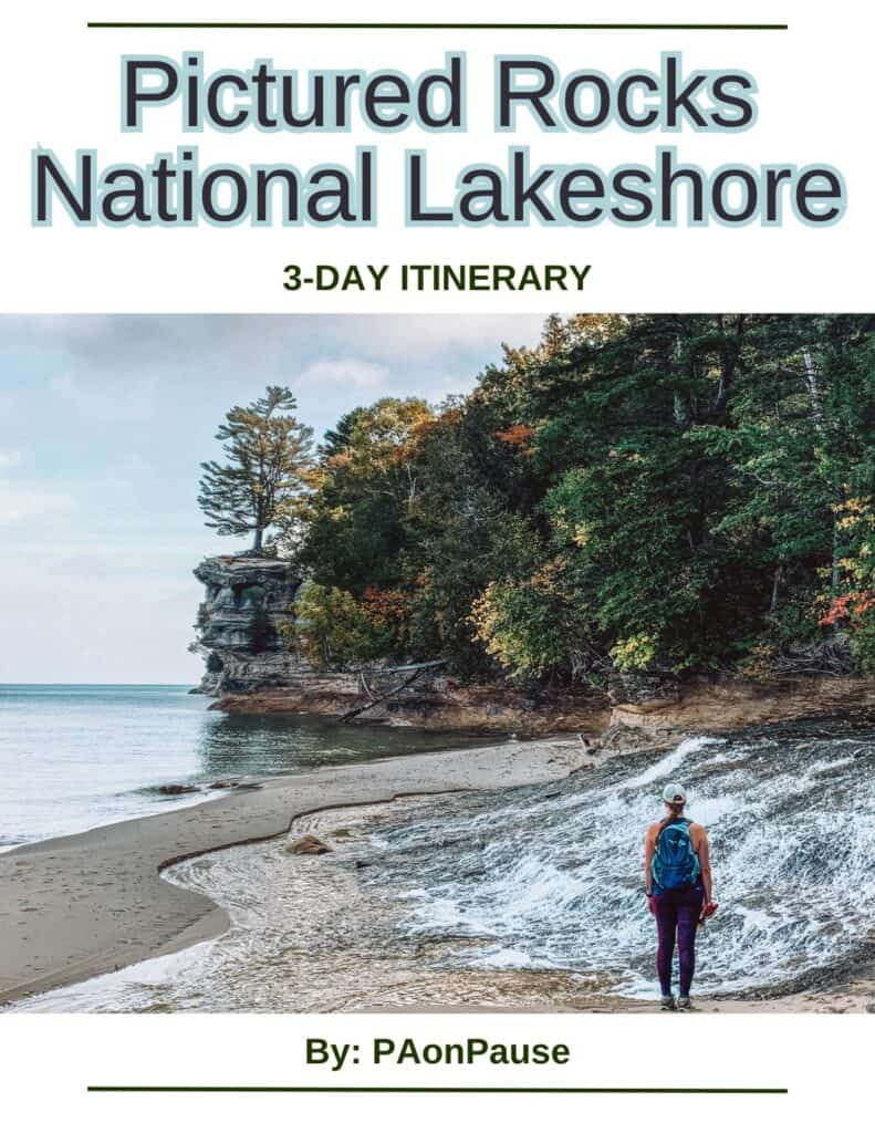
Pictured Rocks Adventures: A Comprehensive Guide to the National Lakeshore

Did you know that there are three National Lakeshores in the US, and Pictured Rocks is the oldest? There is so much room in this 73,236-acre National Lakeshore for your Pictured Rocks adventures to begin!
We spent some time exploring Pictured Rocks National Lakeshore and had a blast! You’ll find some great hikes, beautiful views of Lake Superior, and even camping close to the beach. Pictured Rocks is one of our favorite stops in the UP, and we always recommend this stop on a road trip.
Here are some of the best things to do and see while adventuring through Pictured Rocks National Lakeshore.
Are you feeling overwhelmed with planning your trip to Pictured Rocks?
Check out our premade 3-day Pictured Rocks Itinerary! We’ve planned your days to include all the best stops, hikes, and overlooks.
Plan your Pictured Rocks trip in no time!
Pictured Rocks Adventures: The Best Things to Do
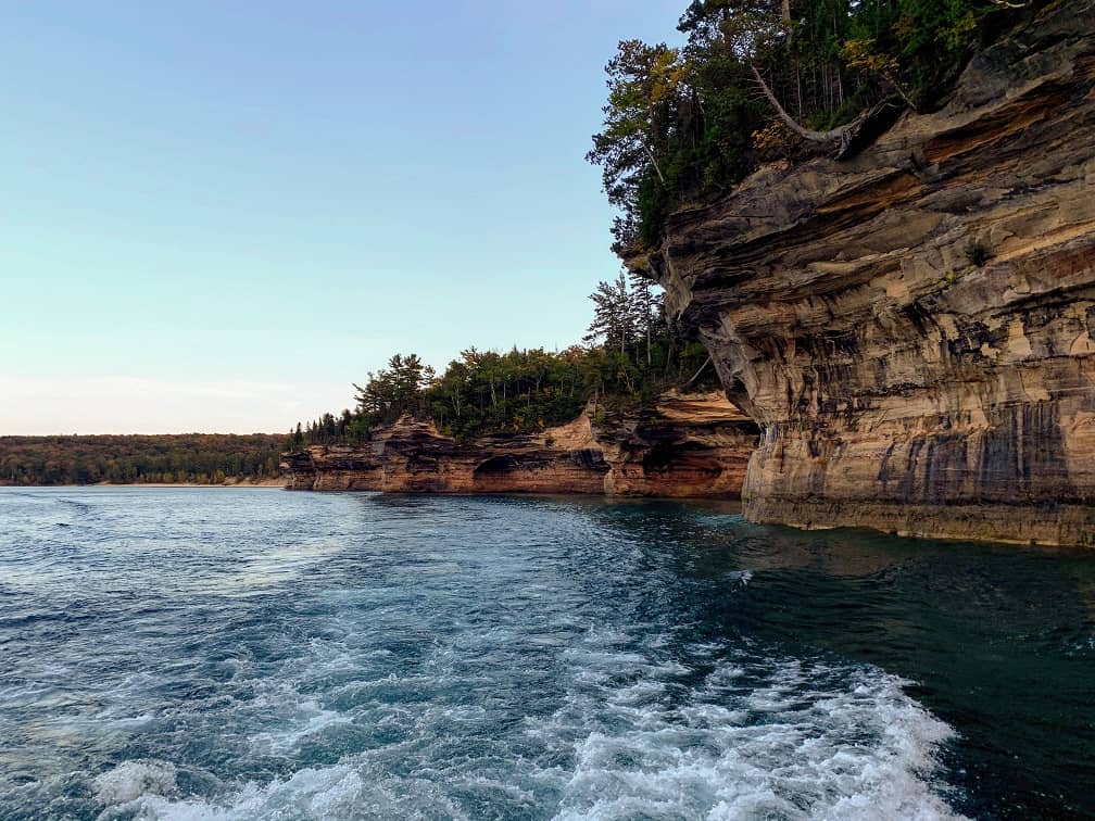
Take a Lake Superior Boat Cruise
Getting out on the water is the best way to see the impressive cliffs and formations from Lake Superior, with the least amount of work!
The tours last 2-3 hours and offer a variety of options to see the cliffs and their beautiful colors and formations.
The cruises also offer the best opportunity to see the shoreline waterfalls straight on, including Spray Falls and Bridalveil Falls.
The narration by the vessel captains can be a little cheesy, but we enjoyed the storytelling. It brought the rock formations to life in a much more imaginative way than my own mind ever could have on its own, while still educating us about the importance and history of the area.
If you only have half of a day to spend in Pictured Rocks, then you should definitely plan to take a Pictured Rocks boat cruise. We’d recommend planning to visit for an afternoon because cruises late in the day are the best!
Taking in a sunset over Lake Superior from a Pictured Rocks cruise is a stunning way to end a day spent in the national lakeshore.
Explore Pictured Rocks with Kayaking Adventures
For those looking to experience the cliffs and Lake Superior with a little bit of a workout, book a Pictured Rocks Kayak Tour. This tour is for those willing to brave the ever-changing Lake Superior waters.
Kayaking is a great way to get up close and personal with the cliffs, but tours do get rescheduled due to weather conditions. If you want to get out on Lake Superior in a kayak, just come prepared to be flexible.
We’d recommend taking a group tour, and there are multiple companies in the area to choose from. Tour lengths vary from a couple of hours to multiday hiking combination adventures.
Discover a shipwreck
Lake Superior is known for swallowing ships in stormy weather. Weather can change by the minute on the lake, and there aren’t many places for the boats to seek safe haven.
Munising Bay, sheltered by Grand Island, is one of the few havens, but entering the bay was difficult for early navigators.
There are 73 known shipwrecks in Munising Bay. With such clear Lake Superior waters, many of them can be viewed through Glass Bottom Boat Tours.
Tours typically run from Memorial Day through the end of September. On the 2-hour tours, you’ll typically get to see two of those ships that are eternally resting in Munising Bay.
Learn history at the Log Slide Overlook
For a little history lesson, stop by the Log Slide Overlook. From the parking lot, the lesson begins.
First, you’ll see the remnants of a cabin in a clearing beside the parking lot where logging workers may have lived. Logging equipment sits in a shelter a little further along the short trail.
The trail ends at the log slide overlook. The elements caused damage to the overlook platform, but the views remain unspoiled.
The logging industry was an important part of the history of the Lakeshore, so be sure to make time to stop at this site. The views alone are worth a stop!

Take in Beautiful Views at Grand Sable Dunes
The huge Grand Sable Dunes are a great place to explore around Pictured Rocks. We didn’t have nearly the same crowds as other points of interest, especially the waterfalls.
The Dunes cover about 5 square miles and exploring these does include difficult walking in soft sand, so be prepared.
You will be rewarded with spectacular views of Lake Superior and a feeling like you are both at the end and on top of the world looking over the 300-foot-high banks.
Leftover from glaciers in the area, the landscape is drastically different from other areas of the park.

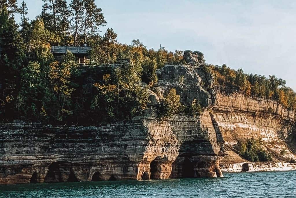
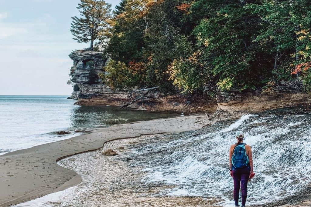
Catch a view of the popular “named” rock formations, like Miner’s Castle…
You won’t have to look far to find a postcard or print of Miner’s Castle, one of the most popular rock formations in Pictured Rocks.
It may look a little different these days because it has been worn from the elements. One of the turrets was lost to the lake in 2006. Three separate overlooks sit just a short walk away from a parking area via a paved path.
It’s one of the most easily accessible views, contributing to its popularity. Just a short visit here will suffice.
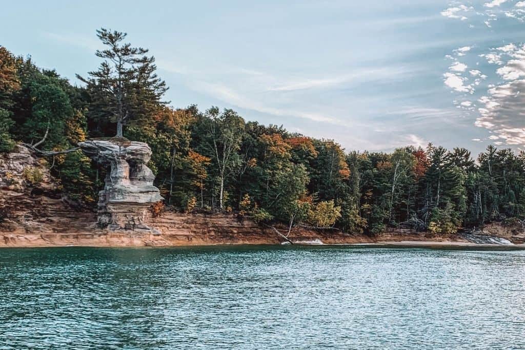
…or Chapel Rock, a Wonder of Nature
Another of the most popular sights sits along Chapel Beach, known as Chapel Rock.
The popular rock is home to a thriving tree around 250 years old, with its roots bridging the gap and extending from the mainland. The roots were once held up by a rock arch, but that collapsed in the 1940s.
The tree hasn’t missed a beat and is now an extremely popular spot to photograph.
The hike to reach Chapel Rock and the beach is one of if not the best, hikes in Michigan. Along the hike, you will find inland lakes, rivers, multiple waterfalls, and old forests.
You’ll need at least half a day to spend exploring these beautiful areas, including the rock via multiple routes of 8-10+ miles of adventure in Pictured Rocks. However, ideally you should plan an entire day to explore the Chapel Rock area.

Explore the Au Sable Light Station
Though it can be seen from various lookout points along the shore, you can hike to the Au Sable Light Station via a 1.5-mile route (each way) on a sandy access road from the Hurricane River Campground.
It’s the tallest light station in the area and you can explore on a guided ranger tour in the warmer months from June through at least September. Tours typically last 30-40 minutes.
Make sure you check out the nearby beach, detailed below, to find washed-up shipwreck remains.
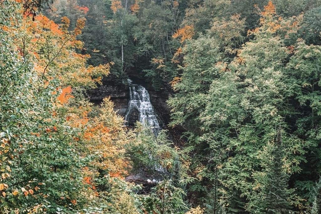
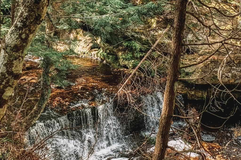
Hike to one of the many breathtaking waterfalls
The topography of the region lends itself perfectly to waterfall formation. Because of this, there are over 300 waterfalls in Michigan’s upper peninsula alone.
This list includes some of the most impressive, and all of these are located within the National Lakeshore.
Munising Falls
This is the closest Pictured Rocks waterfall to the town of Munising.
Munising Falls is 50 feet tall and can be seen at the end of a short, accessible paved path.
There are multiple viewing platforms once reaching the falls, a nice touch because these falls can be quite crowded.

Miners Falls
For a slightly longer hike to another 50-foot-tall waterfall, visit Miner’s Falls. The hike covers just over a mile on a dirt path with mild elevation changes.
This is the most powerful of all the waterfalls in the area, with the most water flow.
There are two viewing areas, one just at the end of the path and the second a short walk down 50+ stairs to a lower platform.
In our opinion, the one at the bottom of the stairs provides a better view. Just know that you’ll also have to climb back up those stairs after you’ve finished checking out the view!
This waterfall hike also gets quite busy during peak seasons and times of the day. It might be difficult to get a parking spot. If it’s full, head down to the Miner’s Castle Overlooks and circle back.
Elliot Falls
Pouring into Lake Superior on Mosquito Beach, you’ll find this small gem.
One of the smallest on this list, Elliot Falls is sometimes dried up during periods of less rain.
When Lake Superior shows its power and the waves are crashing, this small waterfall can be swallowed into the lake.
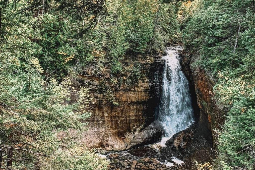
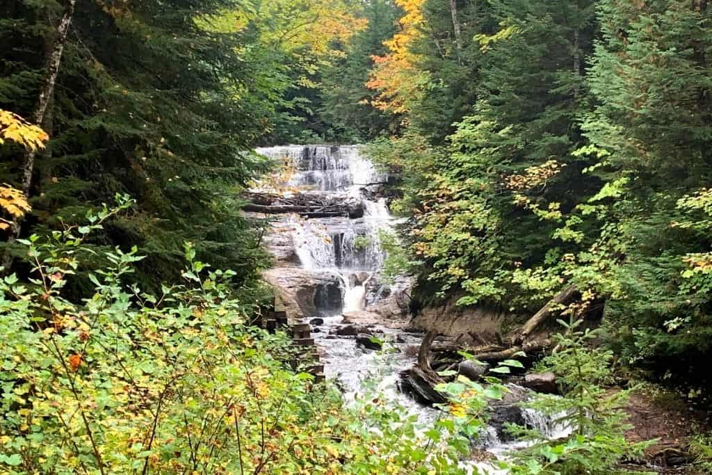
Chapel Falls
Chapel Falls can be found along one of the best hikes in Michigan, by walking through old-growth forests on a wide, well-marked trail. The falls drop about 60 feet into Chapel Lake.
Begin with just over a mile of hiking, and find yourself near two overlooks to take in the scenery.
Combine Chapel Falls, Mosquito Falls, and Chapel Beach for one of the best day hikes in Michigan.
Chapel Beach Falls
Another beach waterfall can be found on the east side of Chapel Beach.
Chapel Creek cascades between the beach and Chapel Rock, with a small wooden footbridge crossing over the creek. You can see a lovely view peak out over Lake Superior from the footbridge.
This is a beautiful, gentle cascade where you can get up close and experience the spray of the falls, not just a view from afar.
Mosquito Falls
Definitely, one of the shorter waterfalls you will come across during your Pictured Rocks adventures, Mosquito Falls can be found nestled among the forested trails. The views aren’t quite as clear as some of the others, but the trail makes for a fun hike.
You’ll find a few quite steep sections of the trail covered in tree roots on this portion. These steep sections are short but a fun challenge.
The drop on the falls here measures about 8 feet.
Combine with Chapel Falls and Beach for over 10 miles of hiking.
Sable Falls
All the way on the east side of the Lakeshore, you will find Sable Falls.
To see this waterfall, you must be able to climb down 168 stairs to the bottom of the valley, then climb back up those same stairs to get back to your vehicle.
The waterfall drops 75 total feet with multiple cascades.
Though the trail to see this waterfall is short, it’s not for the faint of heart due to the many stairs.
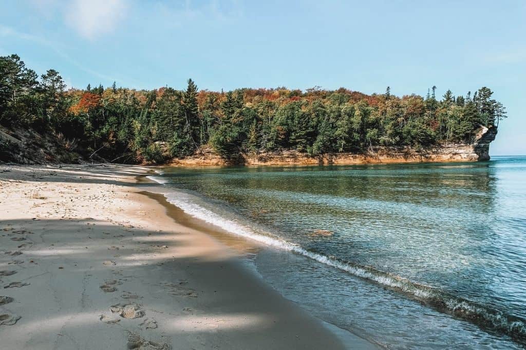
Spend some time on one of the gorgeous Lake Superior Beaches
Beautiful beaches alternate with picturesque colorful cliffs along Lake Superior. Each has its draw, but none are lacking views. Many even provide accessible walkways, overlooks, and access to Lake Superior waters.
Here are the best beaches, in order from west to east, from Munising to Grand Marais.
Sand Point Beach
Sand Point Beach is the closest beach to Munising. This beach has the warmest waters and the smallest waves because it is sheltered by the bay.
This is the best beach for swimming and family-friendly activities because its waters are quite shallow.
Sand Point Beach also has wheelchair-accessible picnic table options and a mat over the sand.
Miner’s Beach
Also easily accessible via a short walk and a set of stairs, Miner’s Beach sits just past Miner’s Castle.
The beach is almost a mile long and is the starting location where many kayak tours launch into Lake Superior. This brings larger crowds in the summer.
This is the best spot to catch beautiful views of Bridalveil Falls at its peak flow in the spring.
Mosquito Beach
Heading to Mosquito Beach is a popular day hiking activity and one of the more difficult beaches to reach. It requires a 4-mile hike.
But with small waterfalls along the way, the hike is never boring.
Catch glimpses of the surrounding cliffs and be rewarded by the seasonal Elliot Falls at the end, when the lake is calmer.
Chapel Beach
Chapel Beach requires the most work to reach, with a hike of no less than 6 miles roundtrip.
The trails are more difficult due to the length, and there are some elevation changes, roots, and rocks along portions of this trail.
The rewards are unmatched views and sights along the way. One of the best Pictured Rocks and Upper Peninsula adventures, this beach has something to see at every angle. This hike was one of the highlights of our trip, and we enjoyed a picnic lunch on the beach before our return hike.
Twelvemile Beach
As (hopefully) obvious from the name, the beach is 12 miles long, with plenty of space and soft sand to enjoy. There are flights of stairs leading down to the beach access.
Twelvemile Beach is located in the middle of Pictured Rocks, and also features a campground with easy access to the water.
Hurricane River Beach
The next beach to come across along the shore is Hurricane River Beach.
This is the most versatile of the Pictured Rocks beaches, always changing looks due to the elements.
Hurricane River Beach is home to the most shipwreck remains found in Pictured Rocks. If you’re looking for a treasure hunt, check out Hurricane River Beach.
Just be sure not to disturb the wreckage; it’s protected by the National Parks Service. If you find remains, you can look, but don’t touch!
The beach is also located near a campground, making it easily accessible.
Sable Falls Beach
Accessible just past Sable Falls on the boardwalk trail, you will find this last Pictured Rocks beach.
Glimpses of the Dunes can be seen from this beach, giving a different vantage point.
This is the rockiest of the beaches, but remember, it is prohibited to remove any of the rocks from the location. You’ll want to have some water shoes to keep your feet more comfortable on this beach.
Backpack the North Country Scenic Trail
42 of the 4,600+ miles of the North Country Trail traverse through Pictured Rocks National Lakeshore. These 42 miles are a fantastic stretch of trail to backpack.
Countless scenic overlooks, waterfalls, and other points of interest line the miles of this trail.
Backcountry campsites can be found every few miles, making the hike appropriate for most skill levels to enjoy the stunning views. Reservations are required for the campsites, so planning ahead is necessary. There is a base fee of $15 per night, plus $5 per person per night for camping, and reservations and fees can be taken care of on Recreation.gov.
Bears are common in the area, so plan ahead and know how to hang your food and scented items.

Upper Peninsula ORV Trails
Heading to the UP? You’ll find no shortage of ATV and ORV trails to enjoy with side-by-sides, 4-wheelers, motorcycles, Jeeps… you name it! Just be sure to check trail restrictions and have permits prior to hitting the trails.
Over 200+ miles connect to both Marquette and Manistique via the nearby National Forests, as well.
If you’d like to experience the trails, but don’t have your own vehicle, check out Grand Marais Powersports or Renze Powersports in the area for rental options.
Save some time to explore the town of Munising
Planning to catch a Pictured Rocks cruise or just passing through? The town of Munising may seem small, but there are plenty of stops worth checking out on your way.
Before you begin your day, grab a breakfast sandwich and a coffee from the Falling Rock Cafe.
Then, stroll through the streets and experience the small-town charm!
End your day around Pictured Rocks with a pint at By George Brewing or East Channel Brewing, both offering a variety of selections for all taste buds.
Do I need a pass to visit Pictured Rocks?
Yes, you will need an entrance pass to visit Pictured Rocks.
In 2024, a seven-day pass to enter Pictured Rocks National Lakeshore lands costs $25 per car. Motorcycle passes are $20 per motorcycle. Walk-in passes cost $15.
Activities such as guided hikes, boat tours, and rentals each have their own fees. More details can be found in the individual adventure descriptions.
Where to stay for your Pictured Rocks adventures?
There are a few different options for lodging near Pictured Rocks. Most of them are going to be found on the west side of the park, around Munising.
Hotels
Hotels are much more plentiful around the Munising area.
Just up the hill out of town, you will find the Holiday Inn Express Munising-Lake View, with reasonably priced and comfortable rooms, many with a balcony view over Munising Bay. We stayed in one of the balcony-view rooms here, and I loved enjoying an early morning cup of coffee out on the small balcony with a view of the bay.
The Roam Inn, right in the town of Munising, is also a great option giving more flexibility to explore the town on foot.
Camping
Camping is the only way to actually spend the night on Pictured Rocks lands.
In addition to the backcountry campsites available along the North Country Scenic Trail, there are three rustic campgrounds dispersed within the Lakeshore boundaries.
Twelvemile Beach Campground (36 sites), Hurricane River Campground (21 sites), and Little Beaver Lake campground (8 sites) each can accommodate tents or campers no longer than 42 feet in length. These sites do not offer any hookups. They can all be reserved on Recreation.gov.
If modern camping is more your style, options sit just outside the Pictured Rocks boundaries.
The Munising Tourist Park Campground just west of Munising offers a variety of sites and hookups, with many sites located right on the beach.
Just a little further west of Munising, the Pictured Rocks RV Park & Campground has full hookups as well as a few cabins available.
For a more familiar name, the Munising/Pictured Rocks KOA is located just south of town and offers both tent and RV sites, as well as cabins.
What else is near Pictured Rocks National Lakeshore?
After you’re satisfied with your Pictured Rocks adventures, plenty of other spots are worth a visit in the UP on a road trip.
For more waterfall experiences, hiking, and camping, check out Tahquamenon Falls State Park. This is the best park to visit while continuing your UP adventures from Pictured Rocks to Tahquamenon Falls!
If you’d like just a short stop on a long drive around the southern shores of the UP, plan a stop and explore Kitch-iti-kipi. The giant fish floating through the cool blue-green waters is peaceful and intriguing.
For more backcountry adventures past Pictured Rocks, head up the shores to Houghton or Copper Harbour to catch a ride out to Isle Royale National Park for a few days of backpacking to enjoy being totally unplugged.
A Few Things to Know When Planning Your Pictured Rocks Adventures
- Cell phone service is terrible in Pictured Rocks. Plan your routes ahead of time and do not rely on service for navigation between trailheads.
- Some access roads to the trailheads are dirt, rough, and not well maintained. Travel can be slow along these routes, so plan drive times accordingly to allow for a little extra travel time.
- Weather on the shores of Lake Superior can change quite quickly. Even if the morning begins with bright sunshine, always be prepared for the elements!
- Pets are permitted in only some parts of the park. Do your research before bringing along your four-legged friends. A complete list of permitted and restricted areas can be found here.
Wrap Up: Should you plan an adventure in Pictured Rocks?
Pictured Rocks is an absolutely beautiful destination in the UP of Michigan, with things to do for weeks. Don’t let the National Lakeshore designation fool you, just because it isn’t a national park.
You won’t be disappointed with any time spent on the shores of Lake Superior.
Are you feeling overwhelmed with planning your trip to Pictured Rocks?
Check out our premade 3-day Pictured Rocks Itinerary! We’ve planned your days to include all the best stops, hikes, and overlooks.
Plan your Pictured Rocks trip in no time!