Hiking in Pictured Rocks National Lakeshore: 15 Trails For Epic Views

Pictured Rocks National Lakeshore is a stunning destination in the Upper Peninsula of Michigan for nature lovers and hikers. With about 100 miles of trails, hikers can explore the park’s sandstone cliffs, waterfalls, and beaches for days! The park is located in Michigan’s Upper Peninsula and is a popular spot for camping, kayaking, and fishing as well.
Hiking in Pictured Rocks offers a unique experience as many of the park’s trails wind along the cliffs overlooking Lake Superior. The famous Chapel Rock and Chapel Beach are must-see destinations! The North Country Trail, which runs through the park, offers hikers a chance to explore even more of the park’s natural beauty on overnight trips.
While hiking in Pictured Rocks can be challenging, it’s a great way to experience the park’s landscapes and have the chance to spot wildlife. Not all the trails are challenging hikes, but hikers should come prepared with proper gear, including sturdy shoes and plenty of water.
With so many trails to choose from, hikers of all levels can find a route that suits them in this stunning national lakeshore.
Short Hikes in Pictured Rocks
Pictured Rocks National Lakeshore is a beautiful destination attracting adventure seekers from around the globe. Known for its turquoise Lake Superior waters, stunning sandstone cliffs, and pine forests, Pictured Rocks is a hiker’s paradise.
While some visitors embark on an epic backpacking trip or explore miles of trails, not everyone has the time or stamina. If you’re looking for an enjoyable way to see some of the best views the park has to offer without breaking too much of a sweat, these short hikes are perfect for you.
Let’s explore the top short trails for hiking in Pictured Rocks. We’ve organized them from west to east along the shore, starting from the town of Munising.
1. Munising Falls
Length: 800 feet (one way)
Surface: Paved
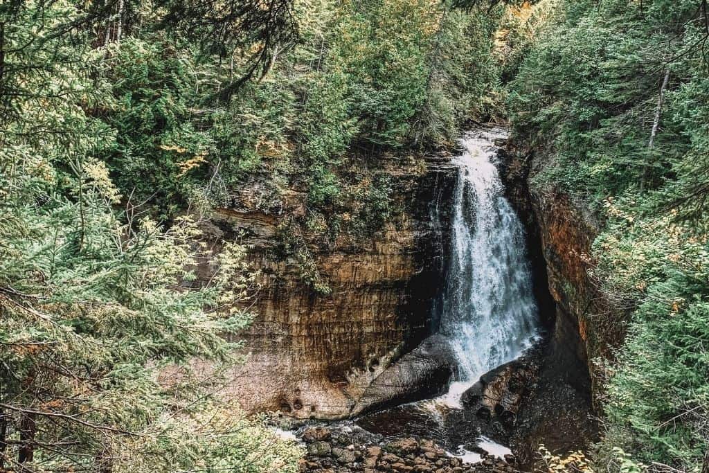
One of the most accessible and popular waterfalls in the Upper Peninsula is Munising Falls, located on the western side of Pictured Rocks National Lakeshore.
This 50-foot tall waterfall can be reached via an 800-foot, mostly paved trail that is a favorite for ice climbers during the winter.
Hikers looking for a quick and easy hike can enjoy this trail without sacrificing beautiful views. The walk up the path is slightly uphill to the falls, but you’ll enjoy the quick downhill on the way back.
The Munising Falls trail features three platforms for overlooks from which visitors can marvel at the waterfall from different angles.
Another plus is that dogs are allowed, but must remain on a leash. It is also possible to navigate this trail with wheelchairs and strollers.

2. Sand Point Marsh
Length: 0.5 miles (loop)
Surface: Boardwalk
Sand Point Marsh is one of the most unique areas within Pictured Rocks National Lakeshore, and it is definitely worth exploring. Located just a short walk from the beach at Sand Point, this is a great trail to explore before or after spending the day at the beach. The marshy wetlands are certainly the star of the show!
One of the most popular activities in Sand Point Marsh is birdwatching. Visitors can catch glimpses of everything from herons, warblers, and sandpipers to eagles and hawks.
Aside from its impressive bird population, Sand Point Marsh also contains a diverse range of flora and fauna. Hiking through this area is a great way to get up close and personal with all of the different plants and animals that call Pictured Rocks home.
If you’re a nature lover, Sand Point Marsh is a must-see when visiting the park. It’s also a great spot to explore with strollers and wheelchairs.
3. Log Slide Overlook
Length: 0.25 miles (out & back)
Surface: Dirt to Sand
Moving even further towards the eastern side of Pictured Rocks National Lakeshore, the Log Slide Overlook is a must-see spot for visitors interested in the history of logging in Michigan’s Upper Peninsula. The overlook provides stunning views of the sand dunes, which were used for the transportation of logs down the 300-foot-descent into Lake Superior via the wooden slide.
The environment surrounding the Log Slide Overlook is peaceful, with a short and fairly easy stretch leading to the overlook itself.
Along the way, you’ll pass by a collection of old logging equipment, where you can get a better idea of how the logging industry used the landscape and took advantage of the natural resources.
Visitors can take a leisurely stroll to enjoy the view, or adventurous hikers can choose to descend the steep sand dunes to reach the shoreline. However, caution should be exercised as the ascent can take upwards of an hour. We wouldn’t suggest it, as there are better ways to spend your time and erosion from the foot traffic up and down the sand can be very damaging.
Pets are not permitted on this trail.
4. Grand Sable Dunes Trail
Length: 0.6 miles (out & back)
Surface: Sand

The Grand Sable Dunes Trail is a destination in Pictured Rocks vastly different from the often seen (and potographed) sandstone cliffs.
For hikers who want to experience the beauty of the sand dunes and their forests, this is a great place to explore. The trail is easily accessible from the Sable Falls parking lot and is a short 0.6-mile hike, making it perfect for those who want to take a quick and easy outing. It can be extended, though, for those who want to do more exploring on the dunes.
The highlight of the Grand Sable Dunes Trail is reaching the sand dunes themselves. These towering dunes offer an opportunity to experience the sheer beauty of Lake Superior’s vast turquoise waters, and they provide a unique perspective on the surrounding wilderness.
This trail is a great option for those who want to experience a shorter hike to access the stunning variety of landscapes in Pictured Rocks National Lakeshore. So, if you’re looking for a quick and easy way to get up close and personal with the sand dunes, the Grand Sable Dunes Trail is definitely worth checking out.
It’s important to note that dogs are not allowed on this trail, so plan accordingly if you’re traveling with your furry friend.
5. Sable Falls Trail
Length: 0.4 miles (out & back)
Surface: Boardwalk Steps
Sable Falls Trail is a must-visit for anyone exploring the Pictured Rocks National Lakeshore. This trail is short and sweet, on the far eastern side of the lakeshore near Grand Marais. It features beautiful views of Sable Falls and continues on to a tranquil beach area.
The main attraction of Sable Falls Trail is its namesake waterfall. This stunning cascade offers views from the trail’s vantage points at different viewing platforms, and the trail includes around 168 stairs down to the waterfall’s base.
Remember, what goes down, must come back up! You’ll be returning the same way that you came, climbing back up those 168 stairs.
Additionally, the beach area at the trail’s end if you continue on past the falls offers a perfect spot to relax before you head back to reach where you parked your car.
Leashed pets are permitted on the stairs and the trail toward the beach. Typically, they’re just not permitted on the sand.
Moderate Hikes in Pictured Rocks
Pictured Rocks National Lakeshore is known for its stunning scenery and breathtaking hikes. While some trails are more challenging, there are also moderate hikes that offer a great experience for hikers of all levels.
No matter which moderate hike you choose, be sure to bring plenty of water and snacks, wear appropriate footwear, and be prepared for changing weather conditions. Always follow Leave No Trace principles and respect the natural environment.
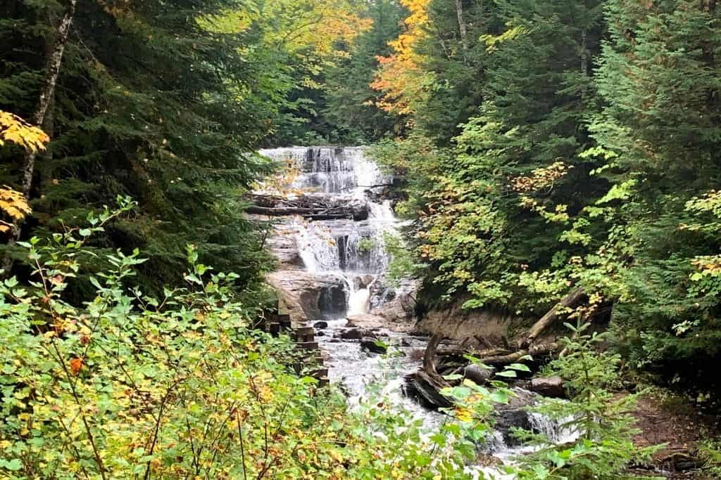
1. Miner’s Falls Trail
Length: 1.2 miles (out & back)
Surface: Paved to Dirt
At 1.2 miles round-trip, the trail is easy and promises stunning views of another powerful Pictured Rocks waterfall, Miner’s Falls.
The trail is perfect for hiking enthusiasts of all skill levels, and it starts at the trailhead located at a small parking lot off Miner’s Castle Road.
As you trek through the forest, you’ll come to two viewing platforms that provide unique views of the 50-foot waterfall in all its glory: one from high above, and one after descending some stairs. The forest is home to an abundance of wildlife, and if you’re lucky, you may spot some along the way.
This is typically a busy hike, as it is not difficult. You may have a little trouble finding parking, but people typically cycle through fairly quickly since it is a short route.
The trail is also dog-friendly, so you can bring your pup on a leash for a hike.
2. Miners Castle to Miners Beach & Elliot Falls
Length: 2 miles (out & back)
Surface: Old access road
The trail between Miners Castle and Miners Beach is a must-visit for any hiker visiting Pictured Rocks. It’s only a 2-mile long hiking trail, but it offers breathtaking views of the turquoise waters of Lake Superior and some of Pictured Rocks’ most notable landmarks.
The trail is considered moderate in difficulty, so it’s recommended for hikers with at least a little experience.
One of the most notable landmarks along the trail is beginning at Miners Castle itself. This sandstone cliff formation is famous for its various overlooks that offer panoramic views of the surrounding pine forests and Lake Superior.
Other noteworthy landmarks include crossing over Miners River on the way to the beach.
As you near the end of the trail, you’ll reach Miners Beach, which is known for its stunning views of the lake. This secluded beach is perfect for a picnic lunch or a relaxing (but cold!) swim after a long hike.
Don’t stop as soon as you reach the beach, though. You’ll find the beautiful little Elliot Falls at the far end of the beach.
While you can drive to these two locations separately, you would miss out on all the fun and the spectacular views from the trail along the way.
This is not a pet-friendly trail.
3. Mosquito Falls
Length: 2 miles (out and back)
Surface: Dirt
One of the highlights of hiking in Pictured Rocks is visiting Mosquito Falls, which is located about 1 mile from the Chapel Basin Trailhead.
The falls are stunning, with the Mosquito River cascading over three rock shelves, the tallest of which is 8 feet. The trail isn’t extremely difficult, but you will have plenty of tree roots to navigate over!
It’s a beautiful sight to see and definitely worth the hike. Keep in mind that even during drier times of the year, this trail can be quite muddy. It might not be the best trail to explore after the spring snow melts or right after very heavy rains.
Also, keep in mind that pets are not allowed on this trail.

4. White Birch Trail
Length: 2 miles (loop)
Surface: Dirt
If you’re looking for a scenic hiking trail in Pictured Rocks, the White Birch Trail is definitely worth checking out. This 2.0-mile loop is an interpretive trail starting at Twelvemile Beach Campground.
It offers a unique opportunity to explore the natural history of the uplands adjacent to the lake. You’ll notice it differs drastically from the area around the campground. You’ll be able to learn a lot about the landscapes and natural settings of this national lakeshore.
Even if you’re not camping, you can still access the trail by parking at the day-use picnic area and walking through the campground. Walk to Site 6, and you’ll see where the trail begins.
The trail will lead you back to the campground road, about 1/4 mile east of the trailhead, where you can then use the campground road to finish the loop.
Leashed pets are allowed on this trail, so you can bring your furry friend along for this adventure.
5. Au Sable Light Station
Length: 3 miles (out & back)
Surface: Old access road
Nestled along the picturesque Pictured Rocks coastline of Lake Superior lies the stunning Au Sable Lighthouse.
This historic landmark was built in 1874 to guide and assist sailors navigating the treacherous waters of the Great Lakes. The shipwreck remains that you can spot along the way are evidence of just how dangerous those Superior waters can be.
Today, hiking the 3-mile trail to this magnificent structure offers a glimpse into its rich history.
The trail is a combination of dirt paths following an old access road and some sandy beach terrain you can explore, making it a perfect hike for most skill levels. Begin from the Hurricane River Campground.
Once you arrive at the lighthouse, you can certainly take one of the available tours to learn more about its history. Tours are available on specific days and are conducted by knowledgeable guides who share fascinating stories and insights into what life was like for the lighthouse keepers who once worked there.
After exploring the light station and the grounds, you’ll turn around and return the way you came, using a short section of the North Country Trail.
Long Hikes in Pictured Rocks
If you’re up for a challenge and want to explore more of Pictured Rocks on foot, then you’re in luck. Pictured Rocks National Lakeshore offers plenty of trails ranging from day hikes to multi-day backpacking trips.
Here are some of the longer hikes in Pictured Rocks that are sure to provide epic views and stunning scenery.
1. Beaver Basin Wilderness Loop
Length: 5.5 miles (loop)
Surface: Dirt
If you’re planning on hiking in Pictured Rocks, you won’t want to miss the Beaver Basin Wilderness Loop. This 5.5-mile loop offers a stunning and varied landscape, taking you through different types of forests, around the picturesque Beaver Lake, and along Beaver Creek, and can include some Lake Superior views.
If you’re looking for a beautiful and moderately challenging hike that showcases the natural beauty of Pictured Rocks, the Beaver Basin Wilderness Loop is definitely worth checking out.
It’s a little more off-the-beaten-path than some of the others we’ve mentioned in this list, so you just might find slightly fewer people on this trail.
It’s important to note that pets are not allowed on this particular trail, so if you’re traveling with furry friends, you may want to consider a different hike.
2. Chapel Loop Trail
Length: 10.5 miles (loop)
Surface: Dirt
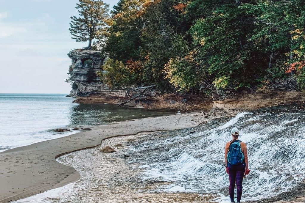
Are you an avid hiker looking for a trail that offers stunning views of waterfalls, sandy beaches, rock formations, and coastline views? The Chapel Loop is where it’s at! Many consider this as not just the best hike in Pictured Rocks or the Upper Peninsula, but the best hike in the entire state of Michigan!
The Chapel Loop Trail offers a unique opportunity for hikers to explore the beauty of the area. The full loop is a 10.5-mile trail that starts at the Chapel Basin parking lot. It is well-signed making it moderate in difficulty. Don’t let the length of the trail scare you away, as it is surprisingly flat, with only a few hills. The steepest part can be found on the descent towards Chapel Rock and Beach.
When hiking Chapel Loop Trail, it is recommended to go counterclockwise to best take in the must-visit spots such as Chapel Falls, Grand Portal Point, Mosquito Beach, and Mosquito Falls. Each of these unique spots offers stunning views and a chance to take a break and enjoy the surroundings.
There are multiple routes in the Chapel Basin, though, where you can shave off distance by leaving off spots like Mosquito Beach or doing an out and back to Mosquito Falls. There are options, so don’t let the distance scare you!
However, be advised that the Chapel Loop Trailhead is a popular spot, which means that the parking lot fills up quickly. It’s best to arrive early and plan accordingly to secure your spot.
3. Grand Portal Point
Length: 8.9 miles (loop)
Surface: Dirt
The Grand Portal Point hike in Pictured Rocks is a must-visit spot for any hiking enthusiast. One of the unique features of this trail is its incredible natural archway, which unfortunately collapsed years ago. However, don’t let that discourage you from experiencing the breathtaking views from the approximately 300-foot height of the area.
To begin your journey to Grand Portal Point, start at the Chapel Basin trailhead. Be prepared for a several-mile hike, and make sure to pack water and snacks, and prepare for the ever-changing weather.
The trail offers stunning vistas along the way, including from the lakeshore and some of the named rock formations along the way including Lover’s Leap and Battleship Rocks. These breathtaking views make the hike to Grand Portal Point well worth the effort.
While you can certainly include the entire Chapel Loop and see most everything on this trail, too, this is a way to shorten the hike and avoid some of the crowds who only travel to Chapel Beach.

4. Spray Falls
Length: 8 miles (out and back)
Surface: Dirt
This trail offers a unique and remote experience through some of Pictured Rocks’ most beautiful landscapes, although Spray Falls itself is best seen from Lake Superior on a boat cruise. This waterfall tumbles down the cliffs, crashing into Lake Superior. It can be difficult to appreciate the wonder from the cliffs to the side.
It can still be a great hike, though, especially if you want to try to get away from some of the crowds on the trail.
To access the trailhead, park at the Little Beaver Trailhead Parking Lot. From here, hikers will begin their journey through the dense woods towards the North Country Trail before reaching the shores of Lake Superior. The trail provides stunning views of Little Beaver Lake, rocky caves, and cliffs that make up the shoreline.
Sitting below the waterfall is an 1856 shipwreck, preserved by the always-cold Lake Superior waters.
Wearing appropriate clothing is essential for this hike. Loose clothing and insect repellent are highly recommended, especially during the summer months when mosquitos and biting flies can be overwhelming. They’ll bite right through fitted clothing like leggings.
The trail includes a few sections of short, steep inclines, but overall, it’s the perfect hike to challenge yourself while taking in the beauty of Pictured Rocks.
5. North Country National Scenic Trail (Lakeshore Trail)
Length: 42 miles (point to point)
Surface: Dirt
One of the most epic hiking experiences in Pictured Rocks National Lakeshore is the North Country Trail, which spans a challenging 42 miles from Grand Marais to Munising.
To embark on this hike, you must first apply for a permit and bring it with you on the trail, which is open seasonally, from April through November
Designated camping areas, which are only available to hikers and some boaters, must be used. Interested hikers can apply for permits through the recreation.gov website.
The North Country Trail is a tough hike, and it is essential to carry adequate water and food supplies. A water bottle with filtration is necessary to refill at water sources along the trail. However, the incredible length and the challenging terrain of the trail are matched by equally impressive highlights.
The most scenic section of the trail runs from Chapel Beach to Mosquito River, where hikers will enjoy breathtaking views along the edge of the cliffs and multiple overlooks. The hike makes its way through pine forests, along sandstone cliffs, and across sandy stretches, too. The secluded backcountry campsites offer a unique wild experience surrounded by nature’s beauty.
While planning for this hike, hikers must keep in mind that pets are generally not permitted on this trail (only in very limited areas), so make sure to plan accordingly. This isn’t the best adventure to bring your dog on.

Hiking in Pictured Rocks: FAQs
Are you planning a trip for hiking in Pictured Rocks and have questions? Look no further! We’ve compiled a list of frequently asked questions to help you prepare for your adventure in this stunning national lakeshore.
Don’t see the answer to your question? Send us a message, and we just might have the answer!
Do you need hiking boots for Pictured Rocks?
When planning a hiking trip in Pictured Rocks, it is important to consider the type of footwear that you will be wearing. Many people wonder if hiking boots are necessary for this type of terrain. The short answer is yes, hiking boots are highly recommended for a comfortable and safe hiking experience.
However, during the summer and early fall months, I had no trouble hiking in my trusty Chaco sandals. I absolutely love those sandals, though, and hike in them all the time. I wouldn’t choose the Chapel Loop to break in a new pair for the first time.
Appropriate footwear can make a huge difference in enjoying a comfortable hike with fewer chances of accidents and injuries. The terrain in Pictured Rocks can be rocky, filled with tree roots, slippery, and challenging at times, thus a sturdy and durable pair of hiking boots can make a world of difference.
Ankle support is also an essential feature to take into account. Pictured Rocks has a mix of flat and rocky terrains, and hiking boots with good ankle support can withstand the rough terrain and surprise obstacles you may come across along the trail.
My Current Favorite Hiking Footwear:


What Time of Year is Best for Hiking in Pictured Rocks?
Pictured Rocks is a hiking enthusiast’s paradise with miles of trails to explore and jaw-dropping sights to behold. But, what time of year is best to hike in Pictured Rocks? The answer is quite simple: summer.
While it is true that some trails can be explored in the winter, it takes much more planning and pre-hike research as the weather conditions in the area can be quite unpredictable. Trails become snow and ice covered, so you won’t be able to navigate them without the proper equipment.
However, visiting Pictured Rocks in the winter does offer the chance to witness the majesty of giant waterfalls turning into ice caves, which provide a unique opportunity to explore the area with an ice cave tour.
Despite the allure of winter and the icy caves, for the best overall hiking experience, aim for the summer months. Summer is hands down the best time to hike in Pictured Rocks. During this time of year, the weather is often mild and pleasant, making it easier to traverse the rugged terrains of the park.
Early fall is also a beautiful time to visit, as the leaves change. The colorful forests provide a great backdrop for the rushing waterfalls during the fall months in mid to late September and very early October.
What is the Longest Hike at Pictured Rocks?
The longest loop hike in Pictured Rocks National Lakeshore is the Chapel Loop Trail, a 10.5-mile trek that takes hikers through some of the park’s most captivating features. The trail starts and ends at the Chapel Trailhead.
The longest point-to-point trail is the section of the North Country National Scenic Trail through the park, spanning 42 miles. You’ll want to take more than one day to enjoy this trail, and there are plenty of primitive campsites along the way where you can enjoy camping in northern Michigan paradise.
Are there Bears at Pictured Rocks?
Yes! Black bears do call Pictured Rocks home.
If you’re planning to go on a hiking or camping trip at Pictured Rocks, it’s essential to be aware of the presence of bears in the area. While encountering bears can be an exhilarating experience, it’s important to be cautious and take the necessary measures to ensure your safety.
Bears are known to frequent the campgrounds at Pictured Rocks, so camping without proper precautions can be dangerous. Fortunately, every campground has bear boxes and poles available for use. These bear boxes and poles are designed to protect your food and toiletries from curious bears.
Bears are attracted to smells, so it’s important to keep your food and toiletries in an airtight container, away from your sleeping area. A carabiner clip can be useful to help hang your food bag or container from a bear pole if a bear box is not readily available.
By staying aware and taking necessary precautions, you should be well prepared in the event you meet a black bear in Pictured Rocks.

Hiking in Pictured Rocks is an experience like no other. From the breathtaking views to the peaceful sounds of nature, it’s a chance to escape and reconnect with the beauty of the outdoors. While there are plenty of ways to enjoy Pictured Rocks, hiking is one of our favorites.
You’ll definitely want to get out on the trails and experience these beautiful views. Better yet, make Pictured Rocks a stop on a big Upper Peninsula Road Trip, or travel from the lakeshore over to Tahquamenon Falls for more waterfalls to explore at the state park.
What are your favorite trails for hiking in Pictured Rocks?