How to Explore the Jonathan Run Trail at Ohiopyle State Park

Exploring Ohiopyle State Park during the busy season through late spring, summer, and fall often means navigating through crowds, especially around its most popular spots. However, for those seeking a little more off-the-beaten-path experience, we have just the trail for you.
The Jonathan Run Trail stands out as one of our favorite hikes among the many trails at Ohiopyle. Tucked away from the main hub, off Holland Hill Road, this trail offers a perfect mix of its waterfalls and forest landscape. We’ve hiked most of the trails in Ohiopyle, but Jonathan Run’s cascading falls left a lasting impression on us.
Whether you’re looking to cover the distance in a couple of hours or combine it with other trails for a full day of adventure, the Jonathan Run Trail is a must-visit in Ohiopyle. Here’s how to have the best experience on one of Ohiopyle’s best-kept secrets.

The Jonathan Run Trail At A Glance:
Distance: 3.2 miles
Trail Type: Out-and-back (+ loop alternative)
Difficulty: Easy-Moderate (+short difficult sections accessing up close falls views
Elevation: ~ 200 feet
How to get to the Jonathan Run Trailhead
To get to the trailhead, you’ll have to get in your car and drive, but not far. This hike isn’t easily accessed from the main hub in town.
The drive is quite easy and covers about 3.5 miles. It should take you less than 10 minutes.
Heading out of town across the bridge towards the Natural Waterslides, take a right onto Ohiopyle Road.
You will continue up the hill, passing a parking lot used to access Cucumber Falls.
After about 1.5 miles, you will come to a crossroads.
Taking a right will lead to the Kentuck Campground. A left turn would take you to Frank Lloyd Wright’s Kentuck Knob in 0.5 miles.
You should continue straight on Holland Hill Road.
After about 1.5 miles, you will see a dirt drive on the right. This is the parking lot for the Jonathan Run Trail.
There is room for around 10 cars and where your adventure will begin.
Hiking the Jonathan Run Trail
From the horseshoe-shaped parking area, the trail leads you down toward Jonathan Run, and you’ll start to see some water fairly quickly. Much of the trail weaves through the forest along the run.
You will continue on this path for over a mile.
You’ll notice the Sugar Run Trail to the left around 1.25 miles into the hike. We’ll get back to that later.

Continue across the footbridge and follow the well-marked and easy-to-follow path.
Around 1.4 miles into the hike, you’ll pass the Kentuck trail on your right.
You’ll notice a small “social” single-track trail leading over the edge of the hill to the left, just past the Kentuck Trail.
The hill is very steep, so remember that you must return the way you came. Going down is much easier than coming back up!
This trail leads to the first waterfall, Upper Jonathan Run Falls. Multiple tiers and rock layers create an interesting falls pattern on this one.
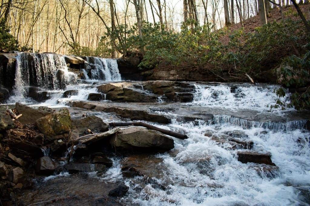
After spending some time exploring and photographing these falls, it’s time to move on! There is plenty more to see.
You can continue along Jonathan Run in the ravine, maybe 20-30 yards downstream, and you’ll find this beautiful little pool fed by a single drop.
It’s only 3-4 feet tall, but the pool can be a beautiful clear aqua color.
It’s also a little more off the beaten path, so it would be a great place to stop for a snack or a picnic lunch by the run. Just remember, you pack it in, and you pack it out! LEAVE NO TRACE!
This small waterfall is unnamed, so we’ve just designated it “Middle” Jonathan Run Falls, instead of “that little one in between, you know?” This isn’t the lower falls. Those are coming later.

After getting your fill of this spot, head back up the side of the ravine, returning to the Jonathan Run Trail to continue on the hike.
Just a few minutes further on the main trail, and you will see another small single-track “social” path, again leading over the edge.
This one is much steeper, and you may notice some ropes anchored to the hillside. This both confirms that you are in the right spot, and can give some reassurance about returning back up the hill to the Jonathan Run Trail.
At the bottom of the hill… which some may describe as a cliff… is where Lower Jonathan Run Falls can be found.
If you don’t feel confident heading down to see this one from the base, check it out from some of the rocky outcroppings. It is easier to see during the seasons when there aren’t a lot of leaves on the trees.
If you’re up for a challenge, adventure to the bottom. You’ll be treated to the taller Lower Jonathan Run Falls.
Although this is the final waterfall actually on the Jonathan Run Trail, there is still more to see, if you’d like!
Connector Trails to Extend Your Hike
About a tenth of a mile or so further, you’ll find the end of the trail, at the intersection of the GAP Trail.
Take a left and follow the GAP Trail, peaking at views of the Youghiogheny River to your right.
Keep an eye out, because after less than 0.2 miles on the GAP Trail, you’ll want to take the Eelah Trail to the left.

From the GAP trail, you are able to see a glimpse of Sugar Run Falls, but continuing up the single-track trail less than one hundred yards will lead directly to the base of the falls.
Trickling over the hillside, Sugar Run Falls is beautiful, fairly easy to access, and worth adding as a stop on this hike.

Here is where decision-making and planning comes in! If you have tired legs, you’ll probably want to turn around and head back the way you came.
To extend into other more remote areas of the park, continue up the steep hill on the Eelah Trail.

This trail is a loop that will eventually lead to the Sugar Run Trail.
Remember, I said we’d get back to this later? For the short connector, take the left at the loop.
Head right for the longer loop that will lead past the parking lot to the Sugar Run Trail, which leads back to the Jonathan Run Trail over 1.6 miles.

Not so fast! We’re not going back to your vehicle just yet!
About 400 yards from the Jonathan Run Trail, just before a wooden footbridge, a small beaten path to the left leads a short distance down the hillside where you will find Fechter Run Falls on the right.
Th is the smallest waterfall of the bunch. There is a good chance of finding solitude at this one. That means plenty of time to snap an unobstructed photo, too!

Returning to the Jonathan Run Trail over a few hundred yards, you’ll then be able to finish the last mile of the hike at the original trailhead. This route covers over 5 miles.
The shorter version, covering around 4 miles, would involve turning around and retracing your steps from Sugar Run Falls, back along the GAP and Jonathan Run trails.
Coming across the Sugar Run Trail, just a few hundred yards, a skip across the wooden footbridge, and a turn will have you at Fechter Falls.
Then, you can return to the parking lot from here, completing one of the best Ohiopyle hiking trails.
Special Notes About the Jonathan Run Trail
- The trail can be quite muddy after rainfall and snowmelt. Plan appropriate footwear!
- This trail could be considered easy-moderate until trying to reach any of the falls on Jonathan Run. We’d consider the side paths to the falls as difficult, especially to the lower falls.
- This is an out-and-back trail. Remember, you will have to retrace any steps that you take. Don’t go down any trail you don’t think you can make it back up.
Other Spots to Visit in Ohiopyle State Park
Ohiopyle is full of beautiful landscapes. Any of the other Ohiopyle waterfalls are worth stopping to see.
Cucumber Falls would be an easy stop on the way back to town, as you’ll drive right past the parking area on the left.
It’s also hard to miss Ohiopyle Falls in town.
If you hiked Jonathan Run on a summer morning, stop at the Natural Waterslides on Meadow Run just before arriving back in town to cool off!
A weekend is not enough to enjoy all of the exciting things to do in Ohiopyle.
For other great hiking trails and waterfalls, check out McConnells Mill State Park. After just a couple of hours of driving, you will find another beautiful spot to explore in Pennsylvania.
Ohiopyle is just one of many PA state parks to find beautiful waterfalls.
Wrapping Up: Hiking the Jonathan Run Trail
While there are other taller and more powerful waterfalls in the park, the Jonathan Run Trail features the most concentrated area of waterfalls.
With crowds flocking to Ohiopyle for rafting and boating adventures on the Youghiogheny River during the summer, it is sometimes difficult to get away from them. This trail is a good place to start.
Also a great hike in the fall, being surrounded by beautiful foliage only adds to the beauty.
Have you hiked the Jonathan Run Trail at Ohiopyle State Park? Did you miss this one on your first visit? Where has been your favorite spot to explore in Ohiopyle?