Hiking Mount Marcy: Ultimate Guide to Day Hiking New York’s Tallest Peak

Are you looking for your next beautiful hiking trail with spectacular views, some terrain variety, and a workout all in one? Hiking Mount Marcy, the tallest peak in the Adirondack Mountains of New York, will certainly provide you with that experience!
There are a few things to know prior to setting out on your first Mount Marcy hiking adventure, and we’re going to fill you in on all the details.
We completed this hike in early August and learned quite a few things along the way. We had a great experience, but it was a busy hike, especially for the distance. Typically, we don’t find quite that many people on trails of this length, but weather conditions were perfect on the day of our hike.
We’ll share all you need to know about where to start, what to expect, and how to go about tackling the Mount Marcy hike in the Adirondacks!
Hiking Mount Marcy At A Glance
Distance: 14.8 miles roundtrip
Duration (book time): 10-11 hours
Elevation: 5,344 feet
Elevation gain: 3,166 feet
Difficulty: Strenuous
First of all, where is Mount Marcy?
Mount Marcy is located in the state of New York, near Lake Placid. You can find this mountain and 45 other “high peaks” originally thought to be over 4,000 feet in the Adirondack Mountains.
From Lake Placid, heading south on Sentinal Road/Route 73, you’ll be at a trailhead in 15-20 minutes.
The best place to begin climbing Mount Marcy is at the Adirondack Loj trailhead. There is lots of parking available, probably for a couple hundred cars.
However, you can use this trailhead to access other high peaks, lakes, and multi-day hikes, so the parking lot does often fill by 8 am during the summer months. If you find the Loj parking full, the next closest parking is 1 mile down the road (read: 2 extra miles of hiking).
Side Note: The 46 high peaks are still considered the originals, even though after they were surveyed, it was found that there are 3 actually a little shorter than 4,000 feet, and one higher peak was left out!
How long does it take to hike Mount Marcy?
Typically, you should plan to do 7-8 hours of actual hiking on your approach and return from the Mount Marcy summit. This does not include time to stop for breaks, snacks, lunch, or take photos.
Everyone does their breaks a little differently, and you know yourself best!
For reference, we were out on the trail for about 9.5 hours. We spent some time exploring Marcy Dam, Indian Falls, and the summit. We also stopped for both a lunch and snack break and would consider ourselves only moderately speedy hikers. However, we typically don’t take long breaks.
By the books, it is recommended to plan 10-11 hours for this hike. You’ll want to plan an early morning and get out on the trail.
When we began this hike, we needed a headlamp to fill out the trail register. By the time we arrived at Marcy Dam, the sunrise had lit up the valley.

Do I need a Reservation to Hike Mount Marcy?
No! This is one of the hikes in the Adirondacks that does not require a reservation to hike.
While the Adirondack Loj, probably the most popular place to begin the hike, does fill early in the morning, there are no technical limits for the number of hikers per day on this mountain.
Mount Marcy Parking & Trailhead
As we just mentioned, the best and most popular place to begin this hike is at the Adirondack Loj.
The parking lot is pretty large, compared to other popular trailheads we’ve used. It’s exponentially bigger than the hiker lot for the AMR, which we used as a base for hiking to Indian Head and Fish Hawk Cliffs.
Parking at the Adirondack Loj lots does require you to pay a $15 fee. This fee must be paid in CASH (or check) when the booth is not staffed. Credit cards are accepted when there is a parking attendant at the booth.
Come prepared. There are no ATMs. Have exactly $15. You’ll fill out an envelope and put your parking fee inside if you arrive early before the booth is staffed, placing the envelope in a fee box, so you won’t get any change.
If you begin your hike early in the morning like we did, the High Peaks Information Center won’t be open yet. However, there are restrooms available in the back of the building which are open 24/7. Take advantage of them once more before you begin!
Trail Options for Reaching the Summit
There are four separate routes to reach the Mount Marcy summit, but by far, the most popular is to begin at the Adirondack Loj & Heart Lake Program Center. That’s what we’re discussing here!
Other options could include beginning at the Johns Brook Lodge Garden trailhead for a 16.6-mile hike.
For more detailed approaches, take a look at the High Peaks maps to plan your trip.
The Adirondack Mountain Club High Peaks guidebook is also a great paper option.
Looking to explore more regions of the Adirondacks? Get the National Geographic Maps Bundle at a discount!
Mount Marcy via Van Hoevenberg Trail
The shortest route for hiking Mount Marcy is via the Van Hoevenberg Trail, which departs from the Adirondack Loj, where the Adirondack Mountains High Peaks Information Center can be found.
Over the 14.6 miles, you’ll gain 3,166 feet of elevation.
➡️Check out AllTrails for recent trail condition reviews and download the offline map.
After you find your parking spot and pay your fee, gather your gear and you’re ready!
To begin the climb up Mount Marcy, you should first stop at the trail register at the trailhead, under the shelter. It is important to leave your name, the number of hikers in your party, the destination, and the number of days you expect your hike to take.
That way, if you get lost, rescue crews would have a general idea of where to start looking! You should never hike without telling someone where you’re headed and when to expect you back, but this is just another safety precaution.
Then, start walking. You’ll begin your hike on the trail covering easy terrain from the Loj for about 2.3 miles, which includes packed dirt with just a few sparse rocks and tree roots. There is a gentle elevation change on this part of the trail.
Remember, this will be a welcome sight on the way back. I know it was for us. We were tired after nearly 9 hours but ready to practically run when we saw this terrain again.

When you reach Marcy Dam 2.2 miles into the hike, stop and take in the views of some of the surrounding peaks including Mount Colden, Avalanche Mountain, and Wright Peak.
We found this a good spot to stop and enjoy a breakfast bar before we continued our hike and the real climb began.
The dam no longer stands as it used to, as Hurricane Irene storms destroyed it in August of 2011. You’ll still see the remnants of what was left behind.
Continue across the wooden bridge just down from the dam site and along the trail.

Pay attention just past the dam! You’ll need to take a separate trail in high water times because crossing the brook on the main trail can be dangerous. There is an alternate high water route 0.5 miles north of Marcy Dam.
Then, after crossing the brook, things get a little more interesting!
The trail begins to climb, and the rocks start to look more like small boulders. To distract you from the climb ahead, listen to the sounds of the water rushing down Phelps Brook just below. You’ll see plenty of small cascades and water features.

This climb seems like it is going to go on forever, but just as you’re ready to give up, the trail flattens out and you’ll come across a small spur trail leading to Indian Falls.
This spur trail comes along just over 4 miles into the hike. This can be a really quick side stop, as Indian Falls is less than 50 yards off the trail.

The view of Indian Falls is from the top, where you’ll see an even better view out over the valley towards some of the other High Peaks. You’re looking at the MacIntyre Range!
This could be a great spot to stop for a snack break or breakfast if you haven’t eaten yet before you continue up the mountain.
About 3 miles are remaining on your trek to the summit. After Indian Falls, the rocks you must climb over seem to get bigger and bigger as you ascend.

With about 1.2 miles left in the hike, the trail flattens out again for a short distance and you’ll get a view of the Marcy summit.
You’ll wonder how you’re going to get up there, and how you’ll reach the top in only about one mile.

The trail turns to more flat bedrock-type alpine terrain, and it’s very open. You’ll be glad that you packed that jacket, even though you were fine in a tank top at the bottom. The winds can be gusty, sometimes over 75 miles per hour!
Sturdy hiking shoes with excellent grip will most certainly help on this part of the trek.
There are a few very steep sections, but soon, you’ll reach the summit.
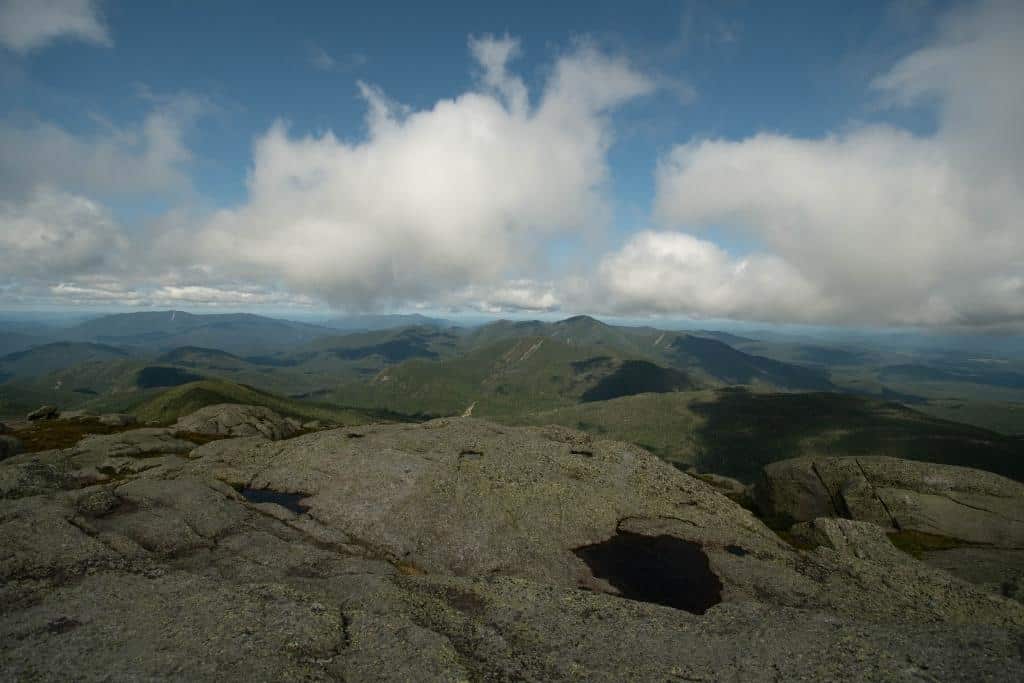
Once at the top, there is plenty of room for people to move around, snap some photos, and relax for a little bit before the descent back down the mountain, or heading on to the next high peak.
Pro Tip: Be sure to watch your step on the summit, which is home to very fragile alpine vegetation. These plants have a very short window for growth and can be easily trampled.

While you’re visiting the alpine area at the summit, take the following precautions to protect the vegetation:
- Limit steps on open rock faces
- Avoid stepping on any plants
- Avoid stepping on loose dirt or gravel
- Follow only the established path
After spending some time at the summit, you’ll have to turn around and head back the way you came, unless you’re heading on to another peak. You’ll probably wonder how you scrambled up over some of those ledges and flat rocks. I know I did!

When is the Best Time to Conquer this Trail?
In Spring, expect to come across more wet conditions and plan to take the high-water route around Phelps Brook.
We’ve found this trail to still be fairly muddy in late summer, so I can only imagine how much mud there is in the spring after all of the snow melts.
Summertime is best to tackle the Mount Marcy hike unless you are very experienced in Adirondack winter hiking. May through October is considered the high season.
Crowds will be largest during summer, so do not expect deserted trails or general solitude on this trail during that time.
Fall brings beautiful colors, but wet fallen leaves on the trail bring an extra challenge.
Winter can be quite dangerous due to wind chills and ice. Be sure to have the appropriate gear, including snowshoes, microspikes, crampons, etc.
Mount Marcy Camping
In the Adirondacks, there is no summit camping permitted and no camping above 3,500 feet.
Because of this, the only location where you can camp along the most popular trail to summit Mount Marcy is at the Marcy Dam.
This is a popular base camp for both Mount Marcy and the other summit over 5,000 feet in New York, Algonquin Peak.
There are a handful of Adirondack-style shelters around Marcy Dam, and around 20 open campsites scattered around the dam area, all marked with round yellow discs. The shelters can accommodate 8 hikers which is the overnight group limit, anyway.
If your group is smaller than 8 and another group could also fit in your shelter, the etiquette is to share!
There are lots of campsites all over Adirondack Park. You can create a multi-day, multi-peak trip by camping at places like Lake Colden or Avalanche Lake.
If you’re looking to make this hike a part of a longer backcountry trip, pick up one of those High Peaks guidebooks. There are so many options. It is difficult to choose!
Pro Tip: If you’re planning to camp in the backcountry, bring your bear canister or rent one locally, like at the High Peaks Information Center.
The bears in the area have outsmarted hanging food, so any type of container they can pick up, they will walk off with.
In the Eastern High Peaks, bears have also outsmarted the clear bearproof canisters.
Where to Stay Near Mount Marcy
While there are camping options nearby, those who are not camping will find great accommodations within about 30 minutes of the Mount Marcy trailheads.
Lake Placid is only about 15 minutes from the trailhead, and the Mirror Lake Inn has some of the best views in town. Many of Lake Placid’s restaurants and shops are within walking distance.
More budget-friendly rooms and cabins can be found at the Cobble Mountain Inn. The mountain lodge decor fits the area and the outdoor fire pits are great to spend a summer evening around enjoying the views.
Top Tips for Hiking Mount Marcy
- Arrive early. You’ll have an easier time securing parking and the temperatures will be much cooler in the summer.
- Check the weather before you go. This hike can get dangerous with rain and wet surfaces on some of the smooth rock surfaces. This is a much more enjoyable hike on a dry day.
- Wear waterproof hiking shoes/boots. The trail can be wet, even in the summer. A 14+ mile hike in wet socks and boots is a recipe for a foot disaster!
- Bring cash for parking if beginning at the Adirondack Loj. You don’t want to lose your parking spot or delay beginning your hike because you forgot your parking money! There is no ATM!
- Pack a windbreaker/layers for the summit. The temperatures are easily 20 degrees different at the top compared to the base. At the High Peaks Information Center, the board informed us that the summit temperature was 48 degrees with a 45-degree wind chill and 6-13 mph winds. This was in mid-August when the high temperature for the day in Lake Placid was 73!
- If you typically hike with trekking or hiking poles, you’ll want to have them on this trip. They can be helpful, especially on the descent. We found ourselves carrying them, though, during the last mile to reach the summit over those smooth rocks.
Hike Combinations (Where to Go After Mount Marcy)
Are you looking for a real challenge? Or looking for a multi-day high peaks adventure?
Hiking Mount Marcy can be combined with several other High Peaks in the area for even more epic adventures. Mount Skylight (4,905′) and Gray Peak (4,800′) are very popular additions, but be warned. You’ll cover over 17 miles on this loop, also beginning at the Adirondack Loj. It is doable in one day, but only for those with appropriate fitness levels.
Peaks within about a mile of the trail include Table Top Mountain (4,304′) and Phelps Mountain (4,140′). The trails split from the Van Hoevenberg Trail. They are well-marked and easily found.
Looking for other things to do around Lake Placid after your hike? There are plenty of things to do, and if you’re visiting during the summer months, things to do around Lake Placid include swimming, kayaking, more hiking, and exploring.
If you’re anything like us, after you’re done hiking for the day, you’re going to be looking for some good food. Maybe a nice frosty beverage.
We really enjoyed:
- Smoke Signals (barbeque) right on the shores of Mirror Lake
- Big Slide Brewing (pizza & subs) on the way back to Lake Placid from the Loj
- Lisa G’s (“creative American) just on the edge of town in Lake Placid

Wrapping-up: Why Hike Mount Marcy?
If you are a summit hiker, this is one sure to be on your list, since it is the tallest peak in the state of New York! If you’re native to the state of New York, you’ve got to see these views of your home state.
And for anyone else… well, the views are pretty spectacular.
If you are looking for a little bit of a challenge or a climbing workout, this is one hike that should not be missed in upstate New York.